Weather Alerts for Colorado
1. Flash Flood Warning for: El Paso, CO
2. Flash Flood Warning for: Las Animas, CO
3. Flood Advisory for: Elbert, CO
4. Flood Advisory for: Morgan, CO; Weld, CO
5. Flood Watch for: Northern Sangre de Cristo Mountains Between 8500 And 11000 Ft; Northern Sangre de Cristo Mountains above 11000 Ft; Southern Sangre De Cristo Mountains Between 7500 and 11000 Ft; Southern Sangre De Cristo Mountains Above 11000 Ft; Northwestern Fremont County Above 8500Ft; Western/Central Fremont County Below 8500 Ft; Wet Mountain Valley Below 8500 Ft; Wet Mountains between 6300 and 10000Ft; Wet Mountains above 10000 Ft; Teller County/Rampart Range above 7500fT/Pike's Peak Between 7500 And 11000 Ft; Pikes Peak above 11000 Ft; Canon City Vicinity/Eastern Fremont County; Northern El Paso County/Monument Ridge/Rampart Range Below 7500 Ft; Colorado Springs Vicinity/Southern El Paso County/Rampart Range Below 7400 Ft; Pueblo Vicinity/Pueblo County Below 6300 Feet; Walsenburg Vicinity/Upper Huerfano River Basin Below 7500 Ft; Trinidad Vicinity/Western Las Animas County Below 7500 Ft
6. Flood Watch for: Roan and Tavaputs Plateaus; Grand Valley; Debeque to Silt Corridor; Central Colorado River Basin; Grand and Battlement Mesas; Gore and Elk Mountains/Central Mountain Valleys; Central Gunnison and Uncompahgre River Basin; West Elk and Sawatch Mountains; Flat Tops; Upper Gunnison River Valley; Uncompahgre Plateau/Dallas Divide; Northwestern San Juan Mountains; Southwest San Juan Mountains; Paradox Valley/Lower Dolores River; Four Corners/Upper Dolores River; Animas River Basin; San Juan River Basin; Southeast Utah; La Sal and Abajo Mountains; Canyonlands/Natural Bridges
Want more detail? Get the Complete 7 Day and Night Detailed Forecast!
Current U.S. National Radar--Current
The Current National Weather Radar is shown below with a UTC Time (subtract 5 hours from UTC to get Eastern Time).

National Weather Forecast--Current
The Current National Weather Forecast and National Weather Map are shown below.

National Weather Forecast for Tomorrow
Tomorrow National Weather Forecast and Tomorrow National Weather Map are show below.

North America Water Vapor (Moisture)
This map shows recent moisture content over North America. Bright and colored areas show high moisture (ie, clouds); brown indicates very little moisture present; black indicates no moisture.

Weather Topic: What are Contrails?
Home - Education - Cloud Types - Contrails
 Next Topic: Cumulonimbus Clouds
A contrail is an artificial cloud, created by the passing of an
aircraft.
Contrails form because water vapor in the exhaust of aircraft engines is suspended
in the air under certain temperatures and humidity conditions. These contrails
are called exhaust contrails.
Another type of contrail can form due to a temporary reduction in air pressure
moving over the plane's surface, causing condensation.
These are called aerodynamic contrails.
When you can see your breath on a cold day, it is also because of condensation.
The reason contrails last longer than the condensation from your breath is
because the water in contrails freezes into ice particles.
Next Topic: Cumulonimbus Clouds
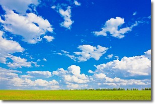
Weather Topic: What are Cumulus Clouds?
Home - Education - Cloud Types - Cumulus Clouds
 Next Topic: Drizzle
Cumulus clouds are fluffy and textured with rounded tops, and
may have flat bottoms. The border of a cumulus cloud
is clearly defined, and can have the appearance of cotton or cauliflower.
Cumulus clouds form at low altitudes (rarely above 2 km) but can grow very tall,
becoming cumulus congestus and possibly the even taller cumulonimbus clouds.
When cumulus clouds become taller, they have a greater chance of producing precipitation.
Next Topic: Drizzle
Current conditions powered by WeatherAPI.com


