Weather Alerts for California
1. Air Quality Alert for: Coachella Valley; San Gorgonio Pass Near Banning
2. Air Quality Alert for: Imperial County Southwest; Imperial County West; Imperial Valley
3. Flood Advisory for: Amador, CA; Calaveras, CA; El Dorado, CA; Nevada, CA; Placer, CA; Sacramento, CA; San Joaquin, CA; Stanislaus, CA; Sutter, CA; Tuolumne, CA; Yolo, CA
4. High Wind Warning for: Death Valley National Park; Esmeralda and Central Nye County
5. Severe Thunderstorm Warning for: Fresno, CA; Madera, CA
6. Severe Thunderstorm Warning for: Fresno, CA; Tulare, CA
7. Special Weather Statement for: Planada - Le Grand - Snelling; Fresno-Clovis; Mariposa Madera Foothills; Mariposa-Madera Lower Sierra; Fresno-Tulare Foothills; Fresno-Tulare Lower Sierra; San Joaquin River Canyon; Upper San Joaquin River; Kaiser to Rodgers Ridge
8. Special Weather Statement for: Sierra Nevada of Tehama-Butte-Plumas Counties Between 1000-3000 ft; Northern Sacramento Valley in Tehama County; Eastern Glenn County; Butte County Below 1000 ft
9. Tornado Warning for: Fresno, CA
10. Wind Advisory for: Apple and Lucerne Valleys; San Diego County Deserts
11. Wind Advisory for: Eastern Sierra Slopes of Inyo County; White Mountains of Inyo County; Owens Valley South; Owens Valley North; Lincoln County
12. Wind Advisory for: Imperial County Southwest
13. Wind Advisory for: Imperial County West; Imperial Valley
14. Wind Advisory for: Indian Wells Valley; Mojave Desert
15. Wind Advisory for: Interstate 5 Corridor; Western San Gabriel Mountains and Highway 14 Corridor; Eastern San Gabriel Mountains; Western Antelope Valley Foothills; Eastern Antelope Valley Foothills; Antelope Valley
16. Wind Advisory for: Joshua Tree NP West
17. Wind Advisory for: Mojave Desert Slopes
18. Wind Advisory for: Riverside County Mountains; San Diego County Mountains
19. Wind Advisory for: San Bernardino County Mountains
20. Wind Advisory for: San Gorgonio Pass Near Banning
21. Winter Storm Warning for: Lassen Volcanic National Park; Sierra Nevada of Tehama-Butte-Plumas Counties Above 3000 ft; Sierra Nevada of Sierra-Nevada-Placer Counties Above 5000 ft Including Interstate 80; Sierra Nevada of El Dorado-Amador-Northern Alpine Counties Above 5000 ft Including Highway 50; Sierra Nevada of Calaveras-Tuolumne-Southern Alpine Counties Above 5000 ft
22. Winter Storm Warning for: Yosemite NP outside of the valley; Upper San Joaquin River; Kaiser to Rodgers Ridge; Kings Canyon NP; Sequoia NP
23. Winter Weather Advisory for: Greater Lake Tahoe Area; Greater Lake Tahoe Area
24. Winter Weather Advisory for: Mono
Want more detail? Get the Complete 7 Day and Night Detailed Forecast!
Current U.S. National Radar--Current
The Current National Weather Radar is shown below with a UTC Time (subtract 5 hours from UTC to get Eastern Time).

National Weather Forecast--Current
The Current National Weather Forecast and National Weather Map are shown below.

National Weather Forecast for Tomorrow
Tomorrow National Weather Forecast and Tomorrow National Weather Map are show below.

North America Water Vapor (Moisture)
This map shows recent moisture content over North America. Bright and colored areas show high moisture (ie, clouds); brown indicates very little moisture present; black indicates no moisture.

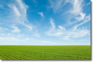
Weather Topic: What are Cirrus Clouds?
Home - Education - Cloud Types - Cirrus Clouds
 Next Topic: Condensation
Cirrus clouds are high-level clouds that occur above 20,000 feet
and are composed mainly of ice crystals.
They are thin and wispy in appearance.
What do they indicate?
They are often the first sign of an approaching storm.
Next Topic: Condensation
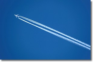
Weather Topic: What are Contrails?
Home - Education - Cloud Types - Contrails
 Next Topic: Cumulonimbus Clouds
A contrail is an artificial cloud, created by the passing of an
aircraft.
Contrails form because water vapor in the exhaust of aircraft engines is suspended
in the air under certain temperatures and humidity conditions. These contrails
are called exhaust contrails.
Another type of contrail can form due to a temporary reduction in air pressure
moving over the plane's surface, causing condensation.
These are called aerodynamic contrails.
When you can see your breath on a cold day, it is also because of condensation.
The reason contrails last longer than the condensation from your breath is
because the water in contrails freezes into ice particles.
Next Topic: Cumulonimbus Clouds
Current conditions powered by WeatherAPI.com


