Weather Alerts for North Carolina
1. Beach Hazards Statement for: Coastal Onslow
2. Beach Hazards Statement for: East Carteret
3. Beach Hazards Statement for: Eastern Currituck; Virginia Beach
4. Beach Hazards Statement for: Northern Outer Banks; Ocracoke Island; Hatteras Island
5. Beach Hazards Statement for: West Carteret
6. Coastal Flood Advisory for: Coastal Brunswick
7. Coastal Flood Advisory for: Coastal Pender; Coastal New Hanover
8. Coastal Flood Advisory for: Inland New Hanover
9. Coastal Flood Advisory for: Pamlico; Southern Craven
10. Coastal Flood Warning for: Coastal Onslow
11. Coastal Flood Warning for: East Carteret
12. Coastal Flood Warning for: Eastern Currituck; Virginia Beach
13. Coastal Flood Warning for: West Carteret
14. Flood Advisory for: Pender, NC
15. Flood Warning for: Jones, NC; Lenoir, NC
16. Flood Warning for: Robeson, NC
17. High Surf Advisory for: Coastal Brunswick
18. High Surf Advisory for: Coastal Onslow
19. High Surf Advisory for: Coastal Pender; Coastal New Hanover
20. High Surf Advisory for: East Carteret
21. High Surf Advisory for: Eastern Currituck; Virginia Beach
22. High Surf Advisory for: Northern Outer Banks; Ocracoke Island; Hatteras Island
23. High Surf Advisory for: West Carteret
24. Rip Current Statement for: Coastal Pender; Coastal New Hanover
25. Storm Surge Warning for: East Carteret
26. Storm Surge Warning for: Hatteras Island
27. Storm Surge Warning for: Northern Outer Banks
28. Storm Surge Warning for: Ocracoke Island
29. Tropical Cyclone Statement for: Mainland Dare; East Carteret; Northern Outer Banks; Ocracoke Island; Hatteras Island
30. Tropical Storm Warning for: East Carteret
31. Tropical Storm Warning for: Eastern Currituck
32. Tropical Storm Warning for: Hatteras Island
33. Tropical Storm Warning for: Mainland Dare
34. Tropical Storm Warning for: Northern Outer Banks
35. Tropical Storm Warning for: Ocracoke Island
36. Tropical Storm Warning for: Western Currituck
37. Wind Advisory for: Pasquotank; Camden; Norfolk/Portsmouth; Chesapeake; Hampton/Poquoson
Want more detail? Get the Complete 7 Day and Night Detailed Forecast!
Current U.S. National Radar--Current
The Current National Weather Radar is shown below with a UTC Time (subtract 5 hours from UTC to get Eastern Time).

National Weather Forecast--Current
The Current National Weather Forecast and National Weather Map are shown below.

National Weather Forecast for Tomorrow
Tomorrow National Weather Forecast and Tomorrow National Weather Map are show below.

North America Water Vapor (Moisture)
This map shows recent moisture content over North America. Bright and colored areas show high moisture (ie, clouds); brown indicates very little moisture present; black indicates no moisture.

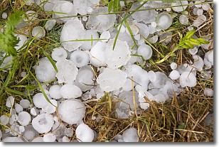
Weather Topic: What is Hail?
Home - Education - Precipitation - Hail
 Next Topic: Hole Punch Clouds
Hail is a form of precipitation which is recognized by large solid balls or
clumps of ice. Hail is created by thunderstorm clouds with strong updrafts of wind.
As the hailstones remain in the updraft, ice is deposited onto them until their
weight becomes heavy enough for them to fall to the earth's surface.
Hail storms can cause significant damage to crops, aircrafts, and man-made structures,
despite the fact that the duration is usually less than ten minutes.
Next Topic: Hole Punch Clouds
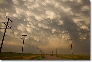
Weather Topic: What are Mammatus Clouds?
Home - Education - Cloud Types - Mammatus Clouds
 Next Topic: Nimbostratus Clouds
A mammatus cloud is a cloud with a unique feature which resembles
a web of pouches hanging along the base of the cloud.
In the United States, mammatus clouds tend to form in the warmer months, commonly
in the Midwest and eastern regions.
While they usually form at the bottom of a cumulonimbis cloud, they can also form
under altostratus, altocumulus, stratocumulus, and cirrus clouds. Mammatus clouds
warn that severe weather is close.
Next Topic: Nimbostratus Clouds
Current conditions powered by WeatherAPI.com


