Weather Alert in Illinois
Flood Warning issued April 4 at 9:40PM CDT until April 10 at 7:00PM CDT by NWS Chicago IL
AREAS AFFECTED: Bureau, IL; La Salle, IL; Putnam, IL
DESCRIPTION: ...The Flood Warning is extended for the following rivers in Illinois... Illinois River at Ottawa affecting La Salle County. ...The Flood Warning continues for the following rivers in Illinois... Illinois River at La Salle affecting Bureau, La Salle and Putnam Counties. * WHAT...Minor flooding is occurring and minor flooding is forecast. * WHERE...Illinois River from Starved Rock Lock and Dam downstream to confluence with Big Bureau Creek, including the La Salle gauge. * WHEN...Until Friday evening. * IMPACTS...At 22.0 feet, Lower parking lot at Starved Rock State Park is inundated east of La Salle. High water levels begin to impact shipping interests along the river. * ADDITIONAL DETAILS... - At 8:45 PM CDT Saturday the stage was 22.3 feet. - Forecast...The river is expected to rise to a crest of 23.9 feet Sunday evening. It will then fall below flood stage early Friday afternoon. - Flood stage is 20.0 feet. - http://www.weather.gov/safety/flood
INSTRUCTION: A Flood Warning means water levels above flood stage are imminent or may already be occurring. Persons along rivers and streams in the warned area should take immediate precautions to protect life and property. These forecasts are based on observed precipitation as well as forecast precipitation 24 hours into the future. Changes to the rainfall forecast, or any additional rainfall after 24 hours, may cause changes to these river forecasts. Additional information is available at www.weather.gov. The next statement will be issued by Sunday afternoon.
Want more detail? Get the Complete 7 Day and Night Detailed Forecast!
Current U.S. National Radar--Current
The Current National Weather Radar is shown below with a UTC Time (subtract 5 hours from UTC to get Eastern Time).

National Weather Forecast--Current
The Current National Weather Forecast and National Weather Map are shown below.

National Weather Forecast for Tomorrow
Tomorrow National Weather Forecast and Tomorrow National Weather Map are show below.

North America Water Vapor (Moisture)
This map shows recent moisture content over North America. Bright and colored areas show high moisture (ie, clouds); brown indicates very little moisture present; black indicates no moisture.

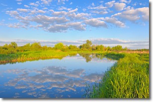
Weather Topic: What are Stratocumulus Clouds?
Home - Education - Cloud Types - Stratocumulus Clouds
 Next Topic: Stratus Clouds
Stratocumulus clouds are similar to altocumulus clouds in their
fluffy appearance, but have a slightly darker shade due to their additional mass.
A good way to distinguish the two cloud types is to hold your hand out and measure
the size of an individual cloud; if it is the size of your thumb it is generally
an altocumulus cloud, if it is the size of your hand it is generally a
stratocumulus cloud.
It is uncommon for stratocumulus clouds to produce precipitation, but if they do
it is usually a light rain or snow.
Next Topic: Stratus Clouds
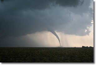
Weather Topic: What are Wall Clouds?
Home - Education - Cloud Types - Wall Clouds
 Next Topic: Altocumulus Clouds
A wall cloud forms underneath the base of a cumulonimbus cloud,
and can be a hotbed for deadly tornadoes.
Wall clouds are formed by air flowing into the cumulonimbus clouds, which can
result in the wall cloud descending from the base of the cumulonimbus cloud, or
rising fractus clouds which join to the base of the storm cloud as the wall cloud
takes shape.
Wall clouds can be very large, and in the Northern Hemisphere they generally
form at the southern edge of cumulonimbus clouds.
Next Topic: Altocumulus Clouds
Current conditions powered by WeatherAPI.com


