Weather Alert in Florida
Flood Warning issued September 2 at 8:57AM EDT until September 7 at 8:00AM EDT by NWS Melbourne FL
AREAS AFFECTED: Lake, FL; Volusia, FL
DESCRIPTION: ...The Flood Warning is extended for the following rivers in Florida... St Johns River Near Astor affecting Lake and Volusia Counties. .On the Saint Johns River at Astor, northerly winds and recent rainfall over the basin are maintaining a slow climb through Minor Flood Stage. The river is forecast to slowly fall late in the week or this weekend to near 2.3 feet. However, additional rainfall or lingering northerly winds could slow the rate of decline. For the St. Johns River...including Astor...Minor flooding is forecast. Additional information is available at www.weather.gov. The next statement will be issued Wednesday afternoon at noon EDT. * WHAT...Minor flooding is occurring and minor flooding is forecast. * WHERE...St Johns River near Astor. * WHEN...Until Sunday morning. * IMPACTS...At 2.8 feet, Docks and boat ramps covered at South Moon Fish Camp and approaching sea wall at Blair's Jungle Den. Water approaching sites closest to the river at Fish Tales RV Resort and Astor Landing Campground. Portion of Clair Street covered by river water south of the Butler Boat Ramp. Docks underwater at the Astor Bridge Marina and along Riveredge Drive. Portions of Fox Road are covered with water nearest to the river. Acorn, Hazelnut and Redbud roads are underwater with yards inundated. * ADDITIONAL DETAILS... - At 8:30 AM EDT Tuesday the stage was 2.6 feet. - Bankfull stage is 2.0 feet. - Recent Activity...The maximum river stage in the 24 hours ending at 8:30 AM EDT Tuesday was 2.6 feet. - Forecast...The river is expected to rise to a crest of 2.8 feet by tomorrow morning. - Flood stage is 2.3 feet. - http://www.weather.gov/safety/flood
INSTRUCTION: N/A
Want more detail? Get the Complete 7 Day and Night Detailed Forecast!
Current U.S. National Radar--Current
The Current National Weather Radar is shown below with a UTC Time (subtract 5 hours from UTC to get Eastern Time).

National Weather Forecast--Current
The Current National Weather Forecast and National Weather Map are shown below.

National Weather Forecast for Tomorrow
Tomorrow National Weather Forecast and Tomorrow National Weather Map are show below.

North America Water Vapor (Moisture)
This map shows recent moisture content over North America. Bright and colored areas show high moisture (ie, clouds); brown indicates very little moisture present; black indicates no moisture.

Weather Topic: What is Freezing Rain?
Home - Education - Precipitation - Freezing Rain
 Next Topic: Graupel
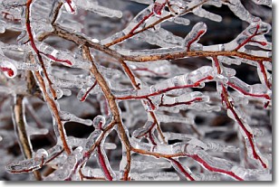
Freezing rain is a condition where precipitation which has fallen in the form of
water droplets reaches temperatures which are below freezing and freezes upon
coming into contact
with surface objects. The result of this precipitation is a glaze of ice which
can be damaging to plants and man-made structures. A severe onset of freezing
rain which results in a very thick glaze of ice is known as an ice storm.
Next Topic: Graupel
Weather Topic: What is Hail?
Home - Education - Precipitation - Hail
 Next Topic: Hole Punch Clouds
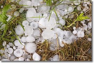
Hail is a form of precipitation which is recognized by large solid balls or
clumps of ice. Hail is created by thunderstorm clouds with strong updrafts of wind.
As the hailstones remain in the updraft, ice is deposited onto them until their
weight becomes heavy enough for them to fall to the earth's surface.
Hail storms can cause significant damage to crops, aircrafts, and man-made structures,
despite the fact that the duration is usually less than ten minutes.
Next Topic: Hole Punch Clouds
Current conditions powered by WeatherAPI.com


