Weather Alert in West Virginia
Special Weather Statement issued February 8 at 8:04PM EST by NWS Charleston WV
AREAS AFFECTED: Northwest Pocahontas; Southeast Pocahontas; Northwest Randolph; Southeast Randolph
DESCRIPTION: High pressure with clear, calm conditions atop the snowpack provide the perfect mid-winter setup for a frigid night and early Monday morning. Temperatures will bottom out in the single digits, single digits below zero in the normally colder low spots away from rivers, even isolated double digit lows below zero in the normally coldest sheltered mountain valleys, particularly for northern portions of Randolph and Pocahontas counties. Even with little or no wind, these low temperatures can lead to frostbite in as little as 30 minutes on exposed skin, as well as hypothermia. Bundle up if you must venture outside anytime tonight through early Monday morning, including the morning commute and bus run. If traveling, be prepared in case of a breakdown.
INSTRUCTION: N/A
Want more detail? Get the Complete 7 Day and Night Detailed Forecast!
Current U.S. National Radar--Current
The Current National Weather Radar is shown below with a UTC Time (subtract 5 hours from UTC to get Eastern Time).

National Weather Forecast--Current
The Current National Weather Forecast and National Weather Map are shown below.

National Weather Forecast for Tomorrow
Tomorrow National Weather Forecast and Tomorrow National Weather Map are show below.

North America Water Vapor (Moisture)
This map shows recent moisture content over North America. Bright and colored areas show high moisture (ie, clouds); brown indicates very little moisture present; black indicates no moisture.

Weather Topic: What are Fractus Clouds?
Home - Education - Cloud Types - Fractus Clouds
 Next Topic: Freezing Rain
A fractus cloud (scud) is a fragmented, tattered cloud which has
likely been sheared off of another cloud. They are accessory clouds, meaning they
develop from parent clouds, and are named in a way which describes the original
cloud which contained them.
Fractus clouds which have originated from cumulus clouds are referred to as
cumulus fractus, while fractus clouds which have originated from stratus clouds
are referred to as stratus fractus. Under certain conditions a fractus cloud might
merge with another cloud, or develop into a cumulus cloud, but usually a
fractus cloud seen by itself will dissipate rapidly.
They are often observed on the leading and trailing edges of storm clouds,
and are a display of wind activity.
Next Topic: Freezing Rain
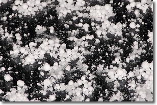
Weather Topic: What is Graupel?
Home - Education - Precipitation - Graupel
 Next Topic: Hail
Graupel is a form of precipitation that is created by atmospheric conditions
which cause supercooled water droplets to contact snow crystals and freeze to
their surface.
Sometimes known as soft hail or snow pellets, graupel is delicate and easily
destroyed by touch. Whereas hail usually falls during severe weather, graupel
doesn't require such conditions to form, and can form in mild precipitation
similar to situations which produce snowfall.
Next Topic: Hail
Current conditions powered by WeatherAPI.com


