Weather Alert in Oregon
Fire Weather Watch issued September 2 at 3:55AM PDT until September 3 at 9:00PM PDT by NWS Portland OR
AREAS AFFECTED: Mt. Hood National Forest Region; Southern Gifford Pinchot National Forest; Mt. Adams Ranger District of the Gifford-Pinchot National Forest
DESCRIPTION: The National Weather Service in Portland has issued a Fire Weather Watch for thunderstorms, which is in effect from Wednesday afternoon through Wednesday evening. * AFFECTED AREA...In Oregon, Fire Weather Zone 688 Mt. Hood National Forest Region. In Washington, Fire Weather Zone 634 Southern Gifford Pinchot National Forest and Fire Weather Zone 635 Mt. Adams Ranger District of the Gifford Pinchot National Forest. * THUNDERSTORMS...A 10-25% chance of thunderstorms. Storms may produce very little rainfall, increasing the risk of new fire starts from dry lightning. * OUTFLOW WINDS...Instantaneous gusts as high as 40 mph. Gusts at these speeds can be observed tens of miles away from the core of the thunderstorm. * DRY AND UNSTABLE...Unstable conditions with elevated mixing heights may promote pyroconvective activity over ongoing fires. * IMPACTS...Conditions may be favorable for rapid fire spread which may threaten life and property. Thunderstorm outflow winds may result in unanticipated erratic fire spread. High instability may result in fire growth. Frequent lightning and critically dry fuels may result in new fire starts.
INSTRUCTION: A Fire Weather Watch means that critical fire weather conditions are forecast to occur. Listen for later forecasts and possible Red Flag Warnings.
Want more detail? Get the Complete 7 Day and Night Detailed Forecast!
Current U.S. National Radar--Current
The Current National Weather Radar is shown below with a UTC Time (subtract 5 hours from UTC to get Eastern Time).

National Weather Forecast--Current
The Current National Weather Forecast and National Weather Map are shown below.

National Weather Forecast for Tomorrow
Tomorrow National Weather Forecast and Tomorrow National Weather Map are show below.

North America Water Vapor (Moisture)
This map shows recent moisture content over North America. Bright and colored areas show high moisture (ie, clouds); brown indicates very little moisture present; black indicates no moisture.

Weather Topic: What is Hail?
Home - Education - Precipitation - Hail
 Next Topic: Hole Punch Clouds
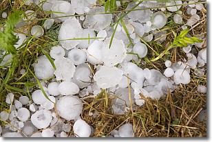
Hail is a form of precipitation which is recognized by large solid balls or
clumps of ice. Hail is created by thunderstorm clouds with strong updrafts of wind.
As the hailstones remain in the updraft, ice is deposited onto them until their
weight becomes heavy enough for them to fall to the earth's surface.
Hail storms can cause significant damage to crops, aircrafts, and man-made structures,
despite the fact that the duration is usually less than ten minutes.
Next Topic: Hole Punch Clouds
Weather Topic: What are Mammatus Clouds?
Home - Education - Cloud Types - Mammatus Clouds
 Next Topic: Nimbostratus Clouds
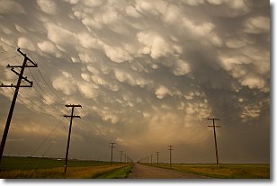
A mammatus cloud is a cloud with a unique feature which resembles
a web of pouches hanging along the base of the cloud.
In the United States, mammatus clouds tend to form in the warmer months, commonly
in the Midwest and eastern regions.
While they usually form at the bottom of a cumulonimbis cloud, they can also form
under altostratus, altocumulus, stratocumulus, and cirrus clouds. Mammatus clouds
warn that severe weather is close.
Next Topic: Nimbostratus Clouds
Current conditions powered by WeatherAPI.com


