Weather Alert in Alaska
Flood Advisory issued September 1 at 9:48AM AKDT until September 4 at 9:15AM AKDT by NWS Anchorage AK
AREAS AFFECTED: Western Susitna Valley; Central Susitna Valley; Northern Susitna Valley
DESCRIPTION: * WHAT...Flooding caused by excessive rainfall is expected. * WHERE...Northern Susitna Valley in the Petersville area * WHEN...Until 915 AM AKDT Thursday. * IMPACTS...Minor flooding in low-lying and poor drainage areas. Rises in small streams. Some low-water crossings may become impassable. River or stream flows are elevated. * ADDITIONAL DETAILS... - 1 to 3 inches of rainfall is expected today (Monday) into tonight (Monday night). The heaviest rain is expected to occur across the headwaters of Peters Creek and Cache Creek. After a lull in rain on Tuesday, another round of rain set to occur on Wednesday is expected to bring another inch of rainfall. - Area creeks and streams are already running higher than normal after the rainfall from last week. While waters have been receding, additional rainfall may result in rises again this week. - Streams that may be affected include Peters Creek, Cache Creek, Moose Creek, Kroto Creek, and other nearby streams and their tributaries. Larger rivers such as that Yentna and Susitna are NOT expected to rise into flood stage again. - http://www.weather.gov/safety/flood
INSTRUCTION: Stay tuned to further developments by listening to your local radio, television, or NOAA Weather Radio for further information. Turn around, don't drown when encountering flooded roads. Most flood deaths occur in vehicles. Flooding is occurring or is imminent. It is important to know where you are relative to streams, rivers, or creeks which can become killers in heavy rains. Campers and hikers should avoid streams or creeks.
Want more detail? Get the Complete 7 Day and Night Detailed Forecast!
Current U.S. National Radar--Current
The Current National Weather Radar is shown below with a UTC Time (subtract 5 hours from UTC to get Eastern Time).

National Weather Forecast--Current
The Current National Weather Forecast and National Weather Map are shown below.

National Weather Forecast for Tomorrow
Tomorrow National Weather Forecast and Tomorrow National Weather Map are show below.

North America Water Vapor (Moisture)
This map shows recent moisture content over North America. Bright and colored areas show high moisture (ie, clouds); brown indicates very little moisture present; black indicates no moisture.

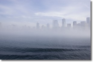
Weather Topic: What is Fog?
Home - Education - Cloud Types - Fog
 Next Topic: Fractus Clouds
Fog is technically a type of stratus cloud, which lies along the
ground and obscures visibility.
It is usually created when humidity in the air condenses into tiny water droplets.
Because of this, some places are more prone to foggy weather, such as regions
close to a body of water.
Fog is similar to mist; both are the appearance of water droplets suspended in
the air, but fog is the term applied to the condition when visibility is less than 1 km.
Next Topic: Fractus Clouds
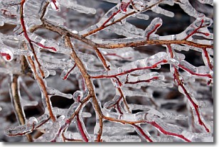
Weather Topic: What is Freezing Rain?
Home - Education - Precipitation - Freezing Rain
 Next Topic: Graupel
Freezing rain is a condition where precipitation which has fallen in the form of
water droplets reaches temperatures which are below freezing and freezes upon
coming into contact
with surface objects. The result of this precipitation is a glaze of ice which
can be damaging to plants and man-made structures. A severe onset of freezing
rain which results in a very thick glaze of ice is known as an ice storm.
Next Topic: Graupel
Current conditions powered by WeatherAPI.com


