Weather Alert in Arkansas
Special Weather Statement issued March 27 at 1:44PM CDT by NWS Shreveport LA
AREAS AFFECTED: Sevier; Howard; Little River; Hempstead; Nevada; Miller; Lafayette; Columbia; Union; Caddo; Bossier; Webster; Claiborne; Lincoln; Union; De Soto; Red River; Bienville; Jackson; Ouachita; Sabine; Natchitoches; Winn; Grant; Caldwell; La Salle; McCurtain; Red River; Bowie; Franklin; Titus; Camp; Morris; Cass; Wood; Upshur; Marion; Smith; Gregg; Harrison; Cherokee; Rusk; Panola; Nacogdoches; Shelby; Angelina; San Augustine; Sabine
DESCRIPTION: Weather conditions will be favorable for wildfire growth. * TIMING: From 11:00 AM Saturday Morning through 7:00 PM Saturday. * RELATIVE HUMIDITY: Afternoon values will range from the 20 to 30 percent range. * WIND: Sustained northeast to east winds around 10-15 mph early in the day with gusts up to 20 mph. Winds will begin to weaken though during the afternoon hours, around the time RH values reach their minimum. * FUELS: Critically dry. These conditions will support the spread of wildfires. Outdoor burning and activities that involve open sparks or flames are discouraged. Please report all wildfires to local law enforcement as soon as possible.
INSTRUCTION: N/A
Want more detail? Get the Complete 7 Day and Night Detailed Forecast!
Current U.S. National Radar--Current
The Current National Weather Radar is shown below with a UTC Time (subtract 5 hours from UTC to get Eastern Time).

National Weather Forecast--Current
The Current National Weather Forecast and National Weather Map are shown below.

National Weather Forecast for Tomorrow
Tomorrow National Weather Forecast and Tomorrow National Weather Map are show below.

North America Water Vapor (Moisture)
This map shows recent moisture content over North America. Bright and colored areas show high moisture (ie, clouds); brown indicates very little moisture present; black indicates no moisture.

Weather Topic: What are Fractus Clouds?
Home - Education - Cloud Types - Fractus Clouds
 Next Topic: Freezing Rain
A fractus cloud (scud) is a fragmented, tattered cloud which has
likely been sheared off of another cloud. They are accessory clouds, meaning they
develop from parent clouds, and are named in a way which describes the original
cloud which contained them.
Fractus clouds which have originated from cumulus clouds are referred to as
cumulus fractus, while fractus clouds which have originated from stratus clouds
are referred to as stratus fractus. Under certain conditions a fractus cloud might
merge with another cloud, or develop into a cumulus cloud, but usually a
fractus cloud seen by itself will dissipate rapidly.
They are often observed on the leading and trailing edges of storm clouds,
and are a display of wind activity.
Next Topic: Freezing Rain
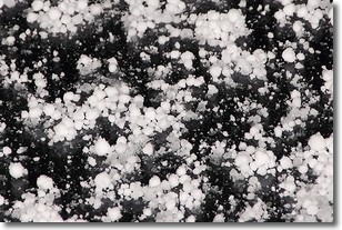
Weather Topic: What is Graupel?
Home - Education - Precipitation - Graupel
 Next Topic: Hail
Graupel is a form of precipitation that is created by atmospheric conditions
which cause supercooled water droplets to contact snow crystals and freeze to
their surface.
Sometimes known as soft hail or snow pellets, graupel is delicate and easily
destroyed by touch. Whereas hail usually falls during severe weather, graupel
doesn't require such conditions to form, and can form in mild precipitation
similar to situations which produce snowfall.
Next Topic: Hail
Current conditions powered by WeatherAPI.com


