Weather Alert in Wisconsin
Flood Warning issued April 4 at 10:52AM CDT until April 8 at 1:00PM CDT by NWS Milwaukee/Sullivan WI
AREAS AFFECTED: Columbia, WI; Sauk, WI
DESCRIPTION: ...The National Weather Service in Milwaukee/Sullivan WI has issued a Flood Warning for the following rivers in Wisconsin... Baraboo River Near Baraboo affecting Columbia and Sauk Counties. * WHAT...Minor flooding is forecast. * WHERE...Baraboo River near Baraboo. * WHEN...From Sunday evening to early Wednesday afternoon. * IMPACTS...At 18.0 feet, If Wisconsin River at Portage up to 17 feet also, water approaches gravel of I-39 off ramp to Cascade Mt Rd. There is widespread flooding of agricultural land. * ADDITIONAL DETAILS... - At 10:00 AM CDT Saturday the stage was 13.7 feet. - Bankfull stage is 14.0 feet. - Forecast...The river is expected to rise above flood stage tomorrow evening to a crest of 18.0 feet Tuesday morning. It will then fall below flood stage Wednesday morning. - Flood stage is 16.0 feet. - Flood History...This crest compares to a previous crest of 18.0 feet on 06/14/1947. - http://www.weather.gov/safety/flood
INSTRUCTION: Motorists should not attempt to drive around barricades or drive cars through flooded areas. Additional information is available at www.weather.gov. The next statement will be issued this evening at 1100 PM CDT.
Want more detail? Get the Complete 7 Day and Night Detailed Forecast!
Current U.S. National Radar--Current
The Current National Weather Radar is shown below with a UTC Time (subtract 5 hours from UTC to get Eastern Time).

National Weather Forecast--Current
The Current National Weather Forecast and National Weather Map are shown below.

National Weather Forecast for Tomorrow
Tomorrow National Weather Forecast and Tomorrow National Weather Map are show below.

North America Water Vapor (Moisture)
This map shows recent moisture content over North America. Bright and colored areas show high moisture (ie, clouds); brown indicates very little moisture present; black indicates no moisture.

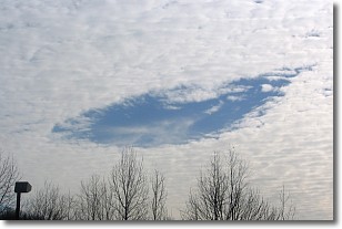
Weather Topic: What are Hole Punch Clouds?
Home - Education - Cloud Types - Hole Punch Clouds
 Next Topic: Mammatus Clouds
A hole punch cloud is an unusual occurrence when a disk-shaped
hole appears in a cirrostratus, cirrocumulus, or altocumulus cloud.
When part of the cloud forms ice crystals, water droplets in the surrounding area
of the cloud evaporate. The effect of this process produces a large elliptical
gap in the cloud. The hole punch cloud formation is rare, but it is not specific
to any geographic area.
Other names which have been used to describe this phenomena include fallstreak hole,
skypunch, and cloud hole.
Next Topic: Mammatus Clouds
Weather Topic: What are Nimbostratus Clouds?
Home - Education - Cloud Types - Nimbostratus Clouds
 Next Topic: Precipitation
A nimbostratus cloud is similar to a stratus cloud in its formless,
smooth appearance. However, a nimbostratus cloud is darker than a stratus cloud,
because it is thicker.
Unlike a stratus cloud, a nimbostratus cloud typically brings with it the threat
of moderate to heavy precipitation. In some cases, the precipitation may evaporate
before reaching the ground, a phenomenon known as virga.
Next Topic: Precipitation
Current conditions powered by WeatherAPI.com


