Weather Alert in Alaska
Special Weather Statement issued March 25 at 4:17PM AKDT by NWS Juneau AK
AREAS AFFECTED: Western Kupreanof and Kuiu Island; Prince of Wales Island; Ketchikan Gateway Borough; Annette Island
DESCRIPTION: A series of low pressure systems will approach the southern panhandle through the end of the work week and into the weekend, with multiple fronts/troughs lifting north through the region. Multiple rounds of snow showers or rain/snow mix are expected for Annette Island, Ketchikan, Prince of Wales Island and Port Alexander. Heavier showers could reduce visibility down to 1/2 mile or less, with snowfall rates as high as 1 inch per hour. One to three inches of snow is possible during the nighttime and early morning hours, as air and surface temperatures hover near to below freezing. Due to the showery nature of the snow, accumulations will be highly variable across the area with expected periods of melting in sunny breaks. Snow showers should diminish through the weekend as surface ridging builds into southeast Alaska. Stay tuned for the latest forecast updates at weather.gov/juneau.
INSTRUCTION: N/A
Want more detail? Get the Complete 7 Day and Night Detailed Forecast!
Current U.S. National Radar--Current
The Current National Weather Radar is shown below with a UTC Time (subtract 5 hours from UTC to get Eastern Time).

National Weather Forecast--Current
The Current National Weather Forecast and National Weather Map are shown below.

National Weather Forecast for Tomorrow
Tomorrow National Weather Forecast and Tomorrow National Weather Map are show below.

North America Water Vapor (Moisture)
This map shows recent moisture content over North America. Bright and colored areas show high moisture (ie, clouds); brown indicates very little moisture present; black indicates no moisture.

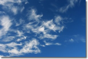
Weather Topic: What are Cirrostratus Clouds?
Home - Education - Cloud Types - Cirrostratus Clouds
 Next Topic: Cirrus Clouds
Cirrostratus clouds are high, thin clouds that form above
20,000 feet and are made mostly of ice crystals. They sometimes look like giant
feathers, horse tails, or curls of hair in the sky.
These clouds are pushed by the jet stream and can move at high speeds reaching
100 mph.
What do they indicate?
They indicate that a precipitation is likely within 24 hours.
Next Topic: Cirrus Clouds
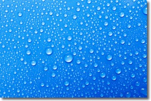
Weather Topic: What is Condensation?
Home - Education - Precipitation - Condensation
 Next Topic: Contrails
Condensation is the process which creates clouds, and therefore
it is a crucial process in the water cycle.
Condensation is the change of matter from a state of gas into a state of liquid,
and it happens because water molecules release heat into the atmosphere and
become organized into a more closely packed structure, what we might see as
water droplets.
Water is always present in the air around us as a vapor, but it's too small for
us to see. When water undergoes the process of condensation it becomes organized
into visible water droplets. You've probably seen condensation happen before on the
surface of a cold drink!
Next Topic: Contrails
Current conditions powered by WeatherAPI.com


