Weather Alert in Oklahoma
Flood Warning issued August 26 at 8:53AM CDT until August 27 at 7:00AM CDT by NWS Norman OK
AREAS AFFECTED: Major, OK; Woods, OK; Woodward, OK
DESCRIPTION: ...The Flood Warning continues for the following rivers in Oklahoma... Cimarron River near Waynoka affecting Major, Woods and Woodward Counties. * WHAT...Minor flooding is forecast. * WHERE...Cimarron River near Waynoka. * WHEN...From this evening to tomorrow morning. * IMPACTS...At 8.0 feet, Bankfull conditions exist along the river... and some overflows may occur over some low-lying areas near the river. The river reach affected extends from near Freedom upstream... to the U.S. Highway 281 crossing south of Little Sahara State Park near Waynoka... to near Orienta in Major County. * ADDITIONAL DETAILS... - At 8:30 AM CDT Tuesday the stage was 6.9 feet. - Bankfull stage is 8.0 feet. - Forecast...The river will rise to flood stage this evening just after midnight tonight. - Flood stage is 8.0 feet. - http://www.weather.gov/safety/flood
INSTRUCTION: Turn around, don't drown when encountering flooded roads. Most flood deaths occur in vehicles. Additional information is available at www.weather.gov.
Want more detail? Get the Complete 7 Day and Night Detailed Forecast!
Current U.S. National Radar--Current
The Current National Weather Radar is shown below with a UTC Time (subtract 5 hours from UTC to get Eastern Time).

National Weather Forecast--Current
The Current National Weather Forecast and National Weather Map are shown below.

National Weather Forecast for Tomorrow
Tomorrow National Weather Forecast and Tomorrow National Weather Map are show below.

North America Water Vapor (Moisture)
This map shows recent moisture content over North America. Bright and colored areas show high moisture (ie, clouds); brown indicates very little moisture present; black indicates no moisture.

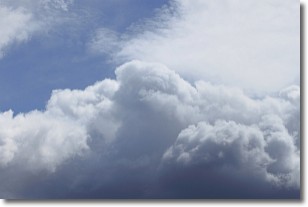
Weather Topic: What are Nimbostratus Clouds?
Home - Education - Cloud Types - Nimbostratus Clouds
 Next Topic: Precipitation
A nimbostratus cloud is similar to a stratus cloud in its formless,
smooth appearance. However, a nimbostratus cloud is darker than a stratus cloud,
because it is thicker.
Unlike a stratus cloud, a nimbostratus cloud typically brings with it the threat
of moderate to heavy precipitation. In some cases, the precipitation may evaporate
before reaching the ground, a phenomenon known as virga.
Next Topic: Precipitation
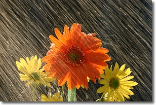
Weather Topic: What is Rain?
Home - Education - Precipitation - Rain
 Next Topic: Shelf Clouds
Precipitation in the form of water droplets is called rain.
Rain generally has a tendency to fall with less intensity over a greater period
of time, and when rainfall is more severe it is usually less sustained.
Rain is the most common form of precipitation and happens with greater frequency
depending on the season and regional influences. Cities have been shown to have
an observable effect on rainfall, due to an effect called the urban heat island.
Compared to upwind, monthly rainfall between twenty and forty miles downwind of
cities is 30% greater.
Next Topic: Shelf Clouds
Current conditions powered by WeatherAPI.com


