Weather Alert in Louisiana
Fire Weather Watch issued March 26 at 12:10PM CDT until March 28 at 7:00PM CDT by NWS New Orleans LA
AREAS AFFECTED: Pointe Coupee; West Feliciana; East Feliciana; St. Helena; Washington; Iberville; West Baton Rouge; East Baton Rouge; Northern Tangipahoa; Southeast St. Tammany; Northern St. Tammany; Southwestern St. Tammany; Central Tangipahoa; Lower Tangipahoa; Northern Livingston; Southern Livingston; Western Ascension; Eastern Ascension; Wilkinson; Amite; Pike; Walthall; Pearl River; Hancock; Harrison; Jackson
DESCRIPTION: ...CRITICAL FIRE WEATHER CONDITIONS POSSIBLE SATURDAY... The National Weather Service in New Orleans has issued a Fire Weather Watch for portions of southeast Louisiana and south Mississippi, which is in effect from Saturday morning through Saturday evening. * AFFECTED AREA...Pointe Coupee, West Feliciana, East Feliciana, St. Helena, Washington, Iberville, West Baton Rouge, East Baton Rouge, Wilkinson, Amite, Pike, Northern Tangipahoa, Walthall, Southeast St. Tammany, Pearl River, Northern St. Tammany, Southwestern St. Tammany, Hancock, Central Tangipahoa, Harrison, Lower Tangipahoa, Jackson, Northern Livingston, Southern Livingston, Western Ascension and Eastern Ascension. * WINDS...Northeast 10 to 15 mph with gusts up to 25 mph. * RELATIVE HUMIDITY...As low as 20 to 25 percent. * IMPACTS...Any fire that develops will catch and spread quickly. Outdoor burning is not recommended.
INSTRUCTION: A Fire Weather Watch means that critical fire weather conditions are forecast to occur. Listen for later forecasts and possible Red Flag Warnings.
Want more detail? Get the Complete 7 Day and Night Detailed Forecast!
Current U.S. National Radar--Current
The Current National Weather Radar is shown below with a UTC Time (subtract 5 hours from UTC to get Eastern Time).

National Weather Forecast--Current
The Current National Weather Forecast and National Weather Map are shown below.

National Weather Forecast for Tomorrow
Tomorrow National Weather Forecast and Tomorrow National Weather Map are show below.

North America Water Vapor (Moisture)
This map shows recent moisture content over North America. Bright and colored areas show high moisture (ie, clouds); brown indicates very little moisture present; black indicates no moisture.

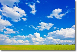
Weather Topic: What are Cumulus Clouds?
Home - Education - Cloud Types - Cumulus Clouds
 Next Topic: Drizzle
Cumulus clouds are fluffy and textured with rounded tops, and
may have flat bottoms. The border of a cumulus cloud
is clearly defined, and can have the appearance of cotton or cauliflower.
Cumulus clouds form at low altitudes (rarely above 2 km) but can grow very tall,
becoming cumulus congestus and possibly the even taller cumulonimbus clouds.
When cumulus clouds become taller, they have a greater chance of producing precipitation.
Next Topic: Drizzle
Weather Topic: What is Evaporation?
Home - Education - Precipitation - Evaporation
 Next Topic: Fog
Evaporation is the process which returns water from the earth
back to the atmosphere, and is another crucial process in the water cycle.
Evaporation is the transformation of liquid into gas, and it happens because
molecules are excited by the application of energy and turn into vapor.
In order for water to evaporate it has to be on the surface of a body of water.
Next Topic: Fog
Current conditions powered by WeatherAPI.com


