Weather Alert in Georgia
Flood Watch issued August 22 at 7:13AM EDT until August 24 at 2:00AM EDT by NWS Charleston SC
AREAS AFFECTED: Jenkins; Screven; Candler; Bulloch; Effingham; Tattnall; Evans; Inland Bryan; Coastal Bryan; Inland Chatham; Coastal Chatham; Long; Inland Liberty; Coastal Liberty; Inland McIntosh; Coastal McIntosh; Allendale; Hampton; Inland Colleton; Dorchester; Inland Berkeley; Inland Jasper; Beaufort; Coastal Colleton; Charleston; Coastal Jasper; Tidal Berkeley
DESCRIPTION: * WHAT...Flash flooding caused by excessive rainfall continues to be possible. * WHERE...Portions of southeast Georgia, including the following areas, Bulloch, Candler, Coastal Bryan, Coastal Chatham, Coastal Liberty, Coastal McIntosh, Effingham, Evans, Inland Bryan, Inland Chatham, Inland Liberty, Inland McIntosh, Jenkins, Long, Screven and Tattnall and southeast South Carolina, including the following areas, Allendale, Beaufort, Charleston, Coastal Colleton, Coastal Jasper, Dorchester, Hampton, Inland Berkeley, Inland Colleton, Inland Jasper and Tidal Berkeley. * WHEN...Through late Saturday night. * IMPACTS...Excessive runoff may result in flooding of rivers, creeks, streams, and other low-lying and flood-prone locations. Creeks and streams may rise out of their banks. Flooding may occur in poor drainage and urban areas. Storm drains and ditches may become clogged with debris. Extensive street flooding and flooding of creeks and rivers are possible. * ADDITIONAL DETAILS... - Numerous to widespread showers and thunderstorms will impact the region Friday through Saturday. Rainfall amounts of 2 to 4 inches can be expected through early Sunday morning with localized amounts exceeding 6 inches. Ground conditions remain wet and any sustained period of heavy rainfall will likely lead to areas of flash flooding. - http://www.weather.gov/safety/flood
INSTRUCTION: Be prepared to protect life and property, especially in areas prone to flooding. If flooding develops, move to higher ground immediately. If driving, be prepared for flooded roadways and possible road closures.
Want more detail? Get the Complete 7 Day and Night Detailed Forecast!
Current U.S. National Radar--Current
The Current National Weather Radar is shown below with a UTC Time (subtract 5 hours from UTC to get Eastern Time).

National Weather Forecast--Current
The Current National Weather Forecast and National Weather Map are shown below.

National Weather Forecast for Tomorrow
Tomorrow National Weather Forecast and Tomorrow National Weather Map are show below.

North America Water Vapor (Moisture)
This map shows recent moisture content over North America. Bright and colored areas show high moisture (ie, clouds); brown indicates very little moisture present; black indicates no moisture.

Weather Topic: What is Rain?
Home - Education - Precipitation - Rain
 Next Topic: Shelf Clouds
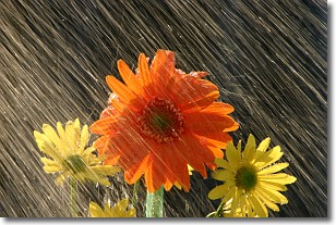
Precipitation in the form of water droplets is called rain.
Rain generally has a tendency to fall with less intensity over a greater period
of time, and when rainfall is more severe it is usually less sustained.
Rain is the most common form of precipitation and happens with greater frequency
depending on the season and regional influences. Cities have been shown to have
an observable effect on rainfall, due to an effect called the urban heat island.
Compared to upwind, monthly rainfall between twenty and forty miles downwind of
cities is 30% greater.
Next Topic: Shelf Clouds
Weather Topic: What is Sleet?
Home - Education - Precipitation - Sleet
 Next Topic: Snow
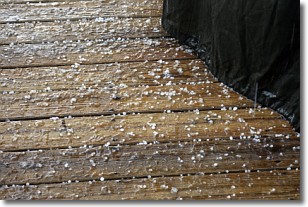
Sleet is a form of precipitation in which small ice pellets are the primary
components. These ice pellets are smaller and more translucent than hailstones,
and harder than graupel. Sleet is caused by specific atmospheric conditions and
therefore typically doesn't last for extended periods of time.
The condition which leads to sleet formation requires a warmer body of air to be
wedged in between two sub-freezing bodies of air. When snow falls through a warmer
layer of air it melts, and as it falls through the next sub-freezing body of air
it freezes again, forming ice pellets known as sleet. In some cases, water
droplets don't have time to freeze before reaching the surface and the result is
freezing rain.
Next Topic: Snow
Current conditions powered by WeatherAPI.com


