Weather Alert in Washington
Fire Weather Watch issued August 21 at 2:15PM PDT until August 23 at 9:00PM PDT by NWS Seattle WA
AREAS AFFECTED: East Portion of the Olympic Mountains
DESCRIPTION: The National Weather Service in Seattle has issued a Fire Weather Watch for hot, dry and unstable conditions, which is in effect from Saturday morning through Saturday evening. * AFFECTED AREA...Fire Weather Zone 661 East Portion of the Olympic Mountains. * RELATIVE HUMIDITY...As low as 25 percent in isolated areas. * TEMPERATURES...Up to 88. * STABILITY...Unstable conditions can be expected * IMPACTS...A dry and unstable air mass with warm temperatures can contribute to active fire behavior. In western Washington, significant growth on existing fires takes place under such conditions. If a fire were to begin, air quality may diminish in the surrounding area.
INSTRUCTION: A Fire Weather Watch means that there is a potential for critical fire weather conditions to develop. Monitor the forecasts for possible Red Flag Warnings.
Want more detail? Get the Complete 7 Day and Night Detailed Forecast!
Current U.S. National Radar--Current
The Current National Weather Radar is shown below with a UTC Time (subtract 5 hours from UTC to get Eastern Time).

National Weather Forecast--Current
The Current National Weather Forecast and National Weather Map are shown below.

National Weather Forecast for Tomorrow
Tomorrow National Weather Forecast and Tomorrow National Weather Map are show below.

North America Water Vapor (Moisture)
This map shows recent moisture content over North America. Bright and colored areas show high moisture (ie, clouds); brown indicates very little moisture present; black indicates no moisture.

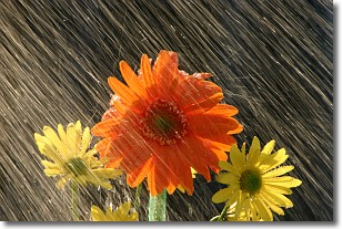
Weather Topic: What is Rain?
Home - Education - Precipitation - Rain
 Next Topic: Shelf Clouds
Precipitation in the form of water droplets is called rain.
Rain generally has a tendency to fall with less intensity over a greater period
of time, and when rainfall is more severe it is usually less sustained.
Rain is the most common form of precipitation and happens with greater frequency
depending on the season and regional influences. Cities have been shown to have
an observable effect on rainfall, due to an effect called the urban heat island.
Compared to upwind, monthly rainfall between twenty and forty miles downwind of
cities is 30% greater.
Next Topic: Shelf Clouds
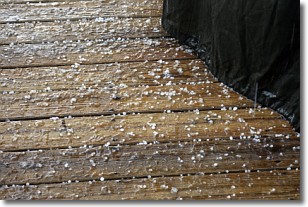
Weather Topic: What is Sleet?
Home - Education - Precipitation - Sleet
 Next Topic: Snow
Sleet is a form of precipitation in which small ice pellets are the primary
components. These ice pellets are smaller and more translucent than hailstones,
and harder than graupel. Sleet is caused by specific atmospheric conditions and
therefore typically doesn't last for extended periods of time.
The condition which leads to sleet formation requires a warmer body of air to be
wedged in between two sub-freezing bodies of air. When snow falls through a warmer
layer of air it melts, and as it falls through the next sub-freezing body of air
it freezes again, forming ice pellets known as sleet. In some cases, water
droplets don't have time to freeze before reaching the surface and the result is
freezing rain.
Next Topic: Snow
Current conditions powered by WeatherAPI.com


