Weather Alert in Washington
Flood Warning issued March 20 at 4:16PM PDT until March 21 at 2:42AM PDT by NWS Seattle WA
AREAS AFFECTED: Whatcom, WA
DESCRIPTION: ...The National Weather Service in Seattle WA has issued a Flood Warning for the following rivers in Washington... Nooksack River At North Cedarville affecting Whatcom County. .Area rivers will continue to rise even as the rain comes to an end. * WHAT...Minor flooding is occurring and minor flooding is forecast. * WHERE...Nooksack River at North Cedarville. * WHEN...From this afternoon to just after midnight tonight. * IMPACTS...At 146.5 feet, the Nooksack River will cause shallow flooding of low pasture lands along the river downstream through Lynden. * ADDITIONAL DETAILS... - At 3:30 PM PDT Friday the stage was 146.6 feet. - Flood stage is 146.5 feet. - Recent Activity...The maximum river stage in the 24 hours ending at 3:30 PM PDT Friday was 146.6 feet. - Forecast...The river is expected to fall below flood stage late this afternoon and continue falling to 140.8 feet late Monday morning. - Flood History...This crest compares to a previous crest of 146.3 feet on 10/17/2009. - http://www.weather.gov/safety/flood
INSTRUCTION: Turn around, don't drown when encountering flooded roads. Most flood deaths occur in vehicles. Additional information is available at www.weather.gov. The next statement will be issued by this evening at 1115 PM PDT.
Want more detail? Get the Complete 7 Day and Night Detailed Forecast!
Current U.S. National Radar--Current
The Current National Weather Radar is shown below with a UTC Time (subtract 5 hours from UTC to get Eastern Time).

National Weather Forecast--Current
The Current National Weather Forecast and National Weather Map are shown below.

National Weather Forecast for Tomorrow
Tomorrow National Weather Forecast and Tomorrow National Weather Map are show below.

North America Water Vapor (Moisture)
This map shows recent moisture content over North America. Bright and colored areas show high moisture (ie, clouds); brown indicates very little moisture present; black indicates no moisture.

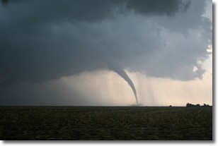
Weather Topic: What are Wall Clouds?
Home - Education - Cloud Types - Wall Clouds
 Next Topic: Altocumulus Clouds
A wall cloud forms underneath the base of a cumulonimbus cloud,
and can be a hotbed for deadly tornadoes.
Wall clouds are formed by air flowing into the cumulonimbus clouds, which can
result in the wall cloud descending from the base of the cumulonimbus cloud, or
rising fractus clouds which join to the base of the storm cloud as the wall cloud
takes shape.
Wall clouds can be very large, and in the Northern Hemisphere they generally
form at the southern edge of cumulonimbus clouds.
Next Topic: Altocumulus Clouds
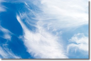
Weather Topic: What are Altostratus Clouds?
Home - Education - Cloud Types - Altostratus Clouds
 Next Topic: Cirrocumulus Clouds
Altostratus clouds form at mid to high-level altitudes
(between 2 and 7 km) and are created by a warm, stable air mass which causes
water vapor
to condense as it rise through the atmosphere. Usually altostratus clouds are
featureless sheets characterized by a uniform color.
In some cases, wind punching through the cloud formation may give it a waved
appearance, called altostratus undulatus. Altostratus clouds
are commonly seen with other cloud formations accompanying them.
Next Topic: Cirrocumulus Clouds
Current conditions powered by WeatherAPI.com


