Weather Alert in Oregon
Heat Advisory issued August 21 at 1:16AM PDT until August 26 at 5:00AM PDT by NWS Portland OR
AREAS AFFECTED: North Oregon Coast Range Lowlands; Central Oregon Coast Range Lowlands; North Oregon Cascades; Cascades of Marion and Linn Counties; Cascades of Lane County; Willapa and Wahkiakum Lowlands; South Washington Cascades
DESCRIPTION: * WHAT...Dangerously hot conditions with high temperatures up to 92-96F and overnight low temperatures of 60-68F possible. * WHERE...South Washington Cascades and the Northern and Central Cascades of Oregon for elevations below 3500 feet, North and Central Coast Range Valleys of Oregon, and Willapa and Wahkiakum Lowlands. * WHEN...From 11 AM Friday to 5 AM PDT Tuesday. * IMPACTS...Heat related illnesses increase significantly during extreme heat events, especially for those spending time outdoors or without access to adequate cooling. * ADDITIONAL DETAILS...Friday and Saturday will be the hottest days.
INSTRUCTION: Drink plenty of fluids, stay in a cool place during the heat of the day, stay out of the sunshine, and check up on relatives and neighbors. For those without air conditioning, use fans to keep air moving. Keeps windows closed during the day and open at night, unless air quality is degraded due to wildfire smoke. Do not leave young children and pets in unattended vehicles. Car interiors will reach lethal temperatures in a matter of minutes. Take extra precautions when outside. Wear lightweight and loose fitting clothing. Try to limit strenuous activities to early morning or evening. Take action when you see symptoms of heat exhaustion and heat stroke.
Want more detail? Get the Complete 7 Day and Night Detailed Forecast!
Current U.S. National Radar--Current
The Current National Weather Radar is shown below with a UTC Time (subtract 5 hours from UTC to get Eastern Time).

National Weather Forecast--Current
The Current National Weather Forecast and National Weather Map are shown below.

National Weather Forecast for Tomorrow
Tomorrow National Weather Forecast and Tomorrow National Weather Map are show below.

North America Water Vapor (Moisture)
This map shows recent moisture content over North America. Bright and colored areas show high moisture (ie, clouds); brown indicates very little moisture present; black indicates no moisture.

Weather Topic: What is Freezing Rain?
Home - Education - Precipitation - Freezing Rain
 Next Topic: Graupel
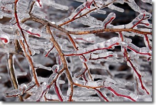
Freezing rain is a condition where precipitation which has fallen in the form of
water droplets reaches temperatures which are below freezing and freezes upon
coming into contact
with surface objects. The result of this precipitation is a glaze of ice which
can be damaging to plants and man-made structures. A severe onset of freezing
rain which results in a very thick glaze of ice is known as an ice storm.
Next Topic: Graupel
Weather Topic: What is Hail?
Home - Education - Precipitation - Hail
 Next Topic: Hole Punch Clouds
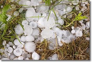
Hail is a form of precipitation which is recognized by large solid balls or
clumps of ice. Hail is created by thunderstorm clouds with strong updrafts of wind.
As the hailstones remain in the updraft, ice is deposited onto them until their
weight becomes heavy enough for them to fall to the earth's surface.
Hail storms can cause significant damage to crops, aircrafts, and man-made structures,
despite the fact that the duration is usually less than ten minutes.
Next Topic: Hole Punch Clouds
Current conditions powered by WeatherAPI.com


