Weather Alert in California
Winter Weather Advisory issued February 7 at 11:36AM PST until February 11 at 4:00PM PST by NWS Sacramento CA
AREAS AFFECTED: Western Plumas County/Lassen Park; West Slope Northern Sierra Nevada
DESCRIPTION: * WHAT...Total snow accumulations 10 to 18 inches above 6000 feet, locally higher over peaks. Snow accumulations 4 to 10 inches above 5000 feet. * WHERE...West Slope Northern Sierra Nevada and Western Plumas County/Lassen Park above 5000 feet. * WHEN...From 10 PM Monday to 4 PM PST Wednesday. * IMPACTS...Mountain travel could be very difficult Tuesday into Wednesday. Plan for delays and chain controls. * ADDITIONAL DETAILS...Heaviest snow expected Tuesday into Tuesday evening.
INSTRUCTION: Check the latest road conditions from Caltrans online at quickmap.dot.ca.gov or dial 5 1 1. Be prepared for slippery roads. Slow down and use caution while driving. The hazardous conditions could make travel difficult with delays and chain controls.
Want more detail? Get the Complete 7 Day and Night Detailed Forecast!
Current U.S. National Radar--Current
The Current National Weather Radar is shown below with a UTC Time (subtract 5 hours from UTC to get Eastern Time).

National Weather Forecast--Current
The Current National Weather Forecast and National Weather Map are shown below.

National Weather Forecast for Tomorrow
Tomorrow National Weather Forecast and Tomorrow National Weather Map are show below.

North America Water Vapor (Moisture)
This map shows recent moisture content over North America. Bright and colored areas show high moisture (ie, clouds); brown indicates very little moisture present; black indicates no moisture.

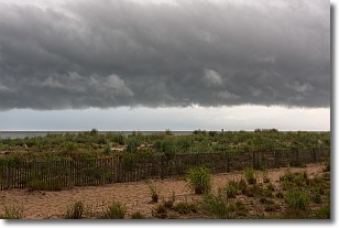
Weather Topic: What are Shelf Clouds?
Home - Education - Cloud Types - Shelf Clouds
 Next Topic: Sleet
A shelf cloud is similar to a wall cloud, but forms at the front
of a storm cloud, instead of at the rear, where wall clouds form.
A shelf cloud is caused by a series of events set into motion by the advancing
storm; first, cool air settles along the ground where precipitation has just fallen.
As the cool air is brought in, the warmer air is displaced, and rises above it,
because it is less dense. When the warmer air reaches the bottom of the storm cloud,
it begins to cool again, and the resulting condensation is a visible shelf cloud.
Next Topic: Sleet
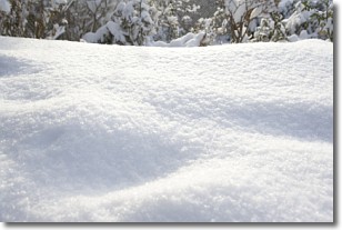
Weather Topic: What is Snow?
Home - Education - Precipitation - Snow
 Next Topic: Stratocumulus Clouds
Snow is precipitation taking the form of ice crystals. Each ice crystal, or snowflake,
has unique characteristics, but all of them grow in a hexagonal structure.
Snowfall can last for sustained periods of time and result in significant buildup
of snow on the ground.
On the earth's surface, snow starts out light and powdery, but as it begins to melt
it tends to become more granular, producing small bits of ice which have the consistency of
sand. After several cycles of melting and freezing, snow can become very dense
and ice-like, commonly known as snow pack.
Next Topic: Stratocumulus Clouds
Current conditions powered by WeatherAPI.com


