Weather Alert in Washington
Fire Weather Watch issued August 22 at 2:08PM PDT until August 26 at 9:00PM PDT by NWS Spokane WA
AREAS AFFECTED: East Washington Central Cascades; East Portion of North Cascades National Park / Lake Chelan National Recreation Area; East Washington North Cascades; Methow Valley
DESCRIPTION: ...HOT, DRY, AND UNSTABLE CONDITIONS FOR MONDAY AND TUESDAY... .A strong ridge of high pressure will bring a period of hot and dry conditions to the central and northern Cascades of Washington this weekend. The ridge will shift east of the Cascades early next week with the atmosphere becoming more unstable at that time. Increased instability with hot and dry conditions will bring the potential for critical fire weather conditions. The National Weather Service in Spokane has issued a Fire Weather Watch for hot, dry, and unstable conditions, which is in effect from Monday afternoon through Tuesday evening. * Affected Area: East Washington Central Cascades (Zone 696), East Portion of North Cascades National Park/Lake Chelan National Recreation Area (Zone 697), East Washington North Cascades (Zone 698) and Methow Valley (Zone 704). * Winds: East-Southeast 3 to 7 mph in the afternoon switching West 5 to 10 mph in the evening. * Timing: Afternoon and evening for both Monday and Tuesday. * Relative Humidities: Below 4,000 feet: 13 to 20 percent. Above 4,000 feet: 20 to 30 percent. * Temperatures: Below 4,000 feet: 90 to 102 degrees. Above 4,000 feet: 75 to 90 degrees. * Impacts: Hot, dry, and unstable conditions may lead to rapid fire growth on any new or existing fires.
INSTRUCTION: A Fire Weather Watch means that critical fire weather conditions are forecast to occur. Listen for later forecasts and possible Red Flag Warnings.
Want more detail? Get the Complete 7 Day and Night Detailed Forecast!
Current U.S. National Radar--Current
The Current National Weather Radar is shown below with a UTC Time (subtract 5 hours from UTC to get Eastern Time).

National Weather Forecast--Current
The Current National Weather Forecast and National Weather Map are shown below.

National Weather Forecast for Tomorrow
Tomorrow National Weather Forecast and Tomorrow National Weather Map are show below.

North America Water Vapor (Moisture)
This map shows recent moisture content over North America. Bright and colored areas show high moisture (ie, clouds); brown indicates very little moisture present; black indicates no moisture.

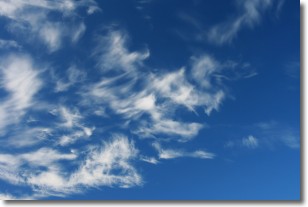
Weather Topic: What are Cirrostratus Clouds?
Home - Education - Cloud Types - Cirrostratus Clouds
 Next Topic: Cirrus Clouds
Cirrostratus clouds are high, thin clouds that form above
20,000 feet and are made mostly of ice crystals. They sometimes look like giant
feathers, horse tails, or curls of hair in the sky.
These clouds are pushed by the jet stream and can move at high speeds reaching
100 mph.
What do they indicate?
They indicate that a precipitation is likely within 24 hours.
Next Topic: Cirrus Clouds
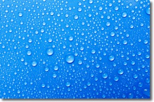
Weather Topic: What is Condensation?
Home - Education - Precipitation - Condensation
 Next Topic: Contrails
Condensation is the process which creates clouds, and therefore
it is a crucial process in the water cycle.
Condensation is the change of matter from a state of gas into a state of liquid,
and it happens because water molecules release heat into the atmosphere and
become organized into a more closely packed structure, what we might see as
water droplets.
Water is always present in the air around us as a vapor, but it's too small for
us to see. When water undergoes the process of condensation it becomes organized
into visible water droplets. You've probably seen condensation happen before on the
surface of a cold drink!
Next Topic: Contrails
Current conditions powered by WeatherAPI.com


