Weather Alert in Wyoming
Winter Weather Advisory issued February 9 at 1:18AM MST until February 9 at 5:00PM MST by NWS Riverton WY
AREAS AFFECTED: Teton and Gros Ventre Mountains
DESCRIPTION: * WHAT...Snow expected. Total snow accumulations of 5 to 12 inches, including over Togwotee and Teton Passes. Locally higher amounts up to 18 inches are possible across the highest terrain of the Tetons. Widespread wind gusts of 20 to 35 mph with the higher terrain of the Tetons seeing gusts up to 50 mph. * WHERE...Teton and Gros Ventre Mountains. * WHEN...Until 5 PM MST this afternoon. * IMPACTS...Travel could be very difficult. The hazardous conditions could impact the Monday morning and evening commutes. * ADDITIONAL DETAILS...The period of heaviest snowfall is forecast to occur through 11 AM Monday with snow rates of 0.5 inch per hour to 1 inch per hour possible.
INSTRUCTION: Slow down and use caution while traveling. For graphical depictions of the snowfall forecast, including the official NWS forecast, high end amounts, and low end amounts, visit https://weather.gov/riw/winter . For winter road conditions from the Wyoming Department of Transportation, visit https://wyoroad.info .
Want more detail? Get the Complete 7 Day and Night Detailed Forecast!
Current U.S. National Radar--Current
The Current National Weather Radar is shown below with a UTC Time (subtract 5 hours from UTC to get Eastern Time).

National Weather Forecast--Current
The Current National Weather Forecast and National Weather Map are shown below.

National Weather Forecast for Tomorrow
Tomorrow National Weather Forecast and Tomorrow National Weather Map are show below.

North America Water Vapor (Moisture)
This map shows recent moisture content over North America. Bright and colored areas show high moisture (ie, clouds); brown indicates very little moisture present; black indicates no moisture.

Weather Topic: What is Condensation?
Home - Education - Precipitation - Condensation
 Next Topic: Contrails
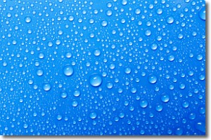
Condensation is the process which creates clouds, and therefore
it is a crucial process in the water cycle.
Condensation is the change of matter from a state of gas into a state of liquid,
and it happens because water molecules release heat into the atmosphere and
become organized into a more closely packed structure, what we might see as
water droplets.
Water is always present in the air around us as a vapor, but it's too small for
us to see. When water undergoes the process of condensation it becomes organized
into visible water droplets. You've probably seen condensation happen before on the
surface of a cold drink!
Next Topic: Contrails
Weather Topic: What are Cumulonimbus Clouds?
Home - Education - Cloud Types - Cumulonimbus Clouds
 Next Topic: Cumulus Clouds
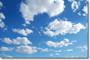
The final form taken by a growing cumulus cloud is the
cumulonimbus cloud, which is very tall and dense.
The tower of a cumulonimbus cloud can soar 23 km into the atmosphere, although
most commonly they stop growing at an altitude of 6 km.
Even small cumulonimbus clouds appear very large in comparison to other cloud types.
They can signal the approach of stormy weather, such as thunderstorms or blizzards.
Next Topic: Cumulus Clouds
Current conditions powered by WeatherAPI.com


