Weather Alert in Kansas
Red Flag Warning issued March 20 at 3:07PM MDT until March 22 at 3:00AM MDT by NWS Goodland KS
AREAS AFFECTED: Rawlins; Decatur; Norton; Thomas; Sheridan; Graham; Logan; Gove; Wichita; Dundy; Hitchcock; Red Willow
DESCRIPTION: Persistently dry conditions and southwesterly wind gusts up to 30 mph are forecast along with record high temperatures. Strongest winds are forecast from around 1 pm to 6 PM CDT. A brief lull in the wind is forecast in the early evening before increasing again during the late evening. Towards the latter part of the warning, a cold front shifting the winds to the north with wind gusts around 45 mph is forecast to move through, this could reinvigorate any smolder fires. * AFFECTED AREA...Fire Weather Zones 002 Rawlins, 003 Decatur, 004 Norton, 014 Thomas, 015 Sheridan, 016 Graham, 028 Logan, 029 Gove, 042 Wichita, 079 Dundy, 080 Hitchcock and 081 Red Willow. * TIMING...From 10 AM MDT /11 AM CDT/ Saturday to 3 AM MDT /4 AM CDT/ Sunday. * WINDS...Southwest 10 to 20 mph with gusts up to 30 mph. * RELATIVE HUMIDITY...As low as 5 percent. * IMPACTS...Unpredictable fire behavior. Any fires that develop may rapidly grow and spread out of control.
INSTRUCTION: Comply with burn bans and regulations. Avoid driving on dry grass or brush. Maintain vehicle brakes and tires and secure tow chains to avoid dragging. Never toss lit cigarettes onto the ground.
Want more detail? Get the Complete 7 Day and Night Detailed Forecast!
Current U.S. National Radar--Current
The Current National Weather Radar is shown below with a UTC Time (subtract 5 hours from UTC to get Eastern Time).

National Weather Forecast--Current
The Current National Weather Forecast and National Weather Map are shown below.

National Weather Forecast for Tomorrow
Tomorrow National Weather Forecast and Tomorrow National Weather Map are show below.

North America Water Vapor (Moisture)
This map shows recent moisture content over North America. Bright and colored areas show high moisture (ie, clouds); brown indicates very little moisture present; black indicates no moisture.

Weather Topic: What is Graupel?
Home - Education - Precipitation - Graupel
 Next Topic: Hail
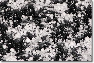
Graupel is a form of precipitation that is created by atmospheric conditions
which cause supercooled water droplets to contact snow crystals and freeze to
their surface.
Sometimes known as soft hail or snow pellets, graupel is delicate and easily
destroyed by touch. Whereas hail usually falls during severe weather, graupel
doesn't require such conditions to form, and can form in mild precipitation
similar to situations which produce snowfall.
Next Topic: Hail
Weather Topic: What are Hole Punch Clouds?
Home - Education - Cloud Types - Hole Punch Clouds
 Next Topic: Mammatus Clouds
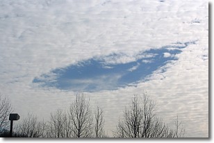
A hole punch cloud is an unusual occurrence when a disk-shaped
hole appears in a cirrostratus, cirrocumulus, or altocumulus cloud.
When part of the cloud forms ice crystals, water droplets in the surrounding area
of the cloud evaporate. The effect of this process produces a large elliptical
gap in the cloud. The hole punch cloud formation is rare, but it is not specific
to any geographic area.
Other names which have been used to describe this phenomena include fallstreak hole,
skypunch, and cloud hole.
Next Topic: Mammatus Clouds
Current conditions powered by WeatherAPI.com


