Weather Alert in Alaska
Special Weather Statement issued September 7 at 4:24PM AKDT by NWS Anchorage AK
AREAS AFFECTED: Central Aleutians
DESCRIPTION: Ex-typhoon Peipah will lift to the Central Aleutians this evening. There will be two separate peaks of strong winds. One this evening with easterly gusts up to 60 mph at times and the last peak, stronger, Monday morning with northerly gusts around 65 mph at times. A few localized gusts up to 70 mph are possible late Monday morning. There will be a break in strong winds early Monday morning as the low pressure center moves by just to the south and east with northerly winds picking up in earnest on the backside of the system mid-Monday morning. Accompanying the strong winds will be moderate to heavy rain this evening through Monday with rainfall totals 2 inches this evening through Monday night. Winds will significantly decrease starting Monday night and into Tuesday. Residents should secure loose items that can easily be blown around or damaged. Prepare for possible power outages. Travel may be difficult.
INSTRUCTION: N/A
Want more detail? Get the Complete 7 Day and Night Detailed Forecast!
Current U.S. National Radar--Current
The Current National Weather Radar is shown below with a UTC Time (subtract 5 hours from UTC to get Eastern Time).

National Weather Forecast--Current
The Current National Weather Forecast and National Weather Map are shown below.

National Weather Forecast for Tomorrow
Tomorrow National Weather Forecast and Tomorrow National Weather Map are show below.

North America Water Vapor (Moisture)
This map shows recent moisture content over North America. Bright and colored areas show high moisture (ie, clouds); brown indicates very little moisture present; black indicates no moisture.

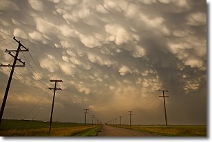
Weather Topic: What are Mammatus Clouds?
Home - Education - Cloud Types - Mammatus Clouds
 Next Topic: Nimbostratus Clouds
A mammatus cloud is a cloud with a unique feature which resembles
a web of pouches hanging along the base of the cloud.
In the United States, mammatus clouds tend to form in the warmer months, commonly
in the Midwest and eastern regions.
While they usually form at the bottom of a cumulonimbis cloud, they can also form
under altostratus, altocumulus, stratocumulus, and cirrus clouds. Mammatus clouds
warn that severe weather is close.
Next Topic: Nimbostratus Clouds
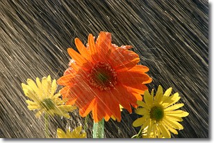
Weather Topic: What is Precipitation?
Home - Education - Precipitation - Precipitation
 Next Topic: Rain
Precipitation can refer to many different forms of water that
may fall from clouds. Precipitation occurs after a cloud has become saturated to
the point where its water particles are more dense than the air below the cloud.
In most cases, precipitation will reach the ground, but it is not uncommon for
precipitation to evaporate before it reaches the earth's surface.
When precipitation evaporates before it contacts the ground it is called Virga.
Graupel, hail, sleet, rain, drizzle, and snow are forms of precipitation, but fog
and mist are not considered precipitation because the water vapor which
constitutes them isn't dense enough to fall to the ground.
Next Topic: Rain
Current conditions powered by WeatherAPI.com


