Weather Alert in Maryland
Coastal Flood Advisory issued August 22 at 6:51AM EDT until August 22 at 12:00PM EDT by NWS Wakefield VA
AREAS AFFECTED: Dorchester; Wicomico; Somerset
DESCRIPTION: * WHAT...For the Coastal Flood Advisory, up to one foot of inundation above ground level in low-lying areas near shorelines and tidal waterways. For the Coastal Flood Warning, one to two feet of inundation above ground level expected in low-lying areas near shorelines and tidal waterways. * WHERE...Dorchester, Wicomico and Somerset Counties. * WHEN...For the Coastal Flood Advisory, until noon EDT today. For the Coastal Flood Warning, from noon today to 8 PM EDT Saturday. * IMPACTS...Widespread flooding of vulnerable areas will result in an elevated threat of property damage to homes and businesses near the waterfront and shoreline. Water will be 1 to 2 feet above ground level in some areas resulting in a sufficient depth to close numerous roads and threaten homes and businesses. Flooding will extend inland from the waterfront along tidal rivers and bays resulting in some road closures and flooding of vehicles.
INSTRUCTION: Take the necessary actions to protect flood-prone property. If travel is required, do not drive around barricades or through water of unknown depth.
Want more detail? Get the Complete 7 Day and Night Detailed Forecast!
Current U.S. National Radar--Current
The Current National Weather Radar is shown below with a UTC Time (subtract 5 hours from UTC to get Eastern Time).

National Weather Forecast--Current
The Current National Weather Forecast and National Weather Map are shown below.

National Weather Forecast for Tomorrow
Tomorrow National Weather Forecast and Tomorrow National Weather Map are show below.

North America Water Vapor (Moisture)
This map shows recent moisture content over North America. Bright and colored areas show high moisture (ie, clouds); brown indicates very little moisture present; black indicates no moisture.

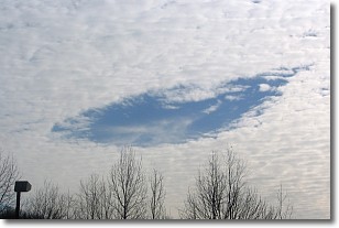
Weather Topic: What are Hole Punch Clouds?
Home - Education - Cloud Types - Hole Punch Clouds
 Next Topic: Mammatus Clouds
A hole punch cloud is an unusual occurrence when a disk-shaped
hole appears in a cirrostratus, cirrocumulus, or altocumulus cloud.
When part of the cloud forms ice crystals, water droplets in the surrounding area
of the cloud evaporate. The effect of this process produces a large elliptical
gap in the cloud. The hole punch cloud formation is rare, but it is not specific
to any geographic area.
Other names which have been used to describe this phenomena include fallstreak hole,
skypunch, and cloud hole.
Next Topic: Mammatus Clouds
Weather Topic: What are Nimbostratus Clouds?
Home - Education - Cloud Types - Nimbostratus Clouds
 Next Topic: Precipitation
A nimbostratus cloud is similar to a stratus cloud in its formless,
smooth appearance. However, a nimbostratus cloud is darker than a stratus cloud,
because it is thicker.
Unlike a stratus cloud, a nimbostratus cloud typically brings with it the threat
of moderate to heavy precipitation. In some cases, the precipitation may evaporate
before reaching the ground, a phenomenon known as virga.
Next Topic: Precipitation
Current conditions powered by WeatherAPI.com


