Weather Alert in Minnesota
Flood Warning issued August 20 at 9:18PM CDT by NWS Twin Cities/Chanhassen MN
AREAS AFFECTED: Chippewa, MN; Renville, MN; Yellow Medicine, MN
DESCRIPTION: ...Forecast flooding changed to Minor severity and increased in duration for the following rivers in Minnesota... Cottonwood River at New Ulm affecting Brown County. Cottonwood River Above Springfield affecting Brown County. ...Forecast flooding changed to Minor severity for the following rivers in Minnesota... Minnesota River at Granite Falls HWY 212 affecting Yellow Medicine, Renville and Chippewa Counties. ...The Flood Warning continues for the following rivers in Minnesota... Minnesota River at Morton affecting Renville and Redwood Counties. Minnesota River at Montevideo affecting Yellow Medicine, Lac qui Parle and Chippewa Counties. * WHAT...Minor flooding is occurring and minor flooding is forecast. * WHERE...Minnesota River at Granite Falls HWY 212. * WHEN...Until further notice. * IMPACTS...At 885.0 feet, Flood waters begin to reach the alley way along the river at the foot bridge. * ADDITIONAL DETAILS... - At 815 PM CDT Wednesday, the stage was 885.7 feet. - The river is slowly rising and nearing crest. - Forecast...The river is expected to rise to a crest of 885.8 feet Friday afternoon. - Flood stage is 885.0 feet. - Flood History...This crest compares to a previous crest of 886.0 feet on 06/22/2012.
INSTRUCTION: Turn around, don't drown when encountering flooded roads. Most flood deaths occur in vehicles. Motorists should not attempt to drive around barricades or drive cars through flooded areas. Caution is urged when walking near riverbanks.
Want more detail? Get the Complete 7 Day and Night Detailed Forecast!
Current U.S. National Radar--Current
The Current National Weather Radar is shown below with a UTC Time (subtract 5 hours from UTC to get Eastern Time).

National Weather Forecast--Current
The Current National Weather Forecast and National Weather Map are shown below.

National Weather Forecast for Tomorrow
Tomorrow National Weather Forecast and Tomorrow National Weather Map are show below.

North America Water Vapor (Moisture)
This map shows recent moisture content over North America. Bright and colored areas show high moisture (ie, clouds); brown indicates very little moisture present; black indicates no moisture.

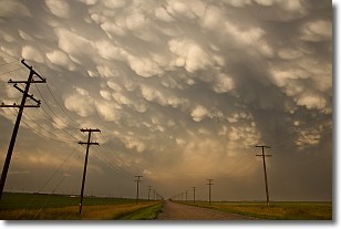
Weather Topic: What are Mammatus Clouds?
Home - Education - Cloud Types - Mammatus Clouds
 Next Topic: Nimbostratus Clouds
A mammatus cloud is a cloud with a unique feature which resembles
a web of pouches hanging along the base of the cloud.
In the United States, mammatus clouds tend to form in the warmer months, commonly
in the Midwest and eastern regions.
While they usually form at the bottom of a cumulonimbis cloud, they can also form
under altostratus, altocumulus, stratocumulus, and cirrus clouds. Mammatus clouds
warn that severe weather is close.
Next Topic: Nimbostratus Clouds
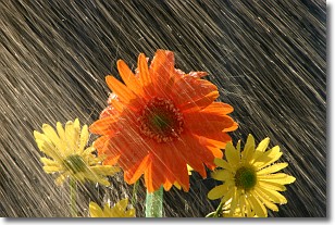
Weather Topic: What is Precipitation?
Home - Education - Precipitation - Precipitation
 Next Topic: Rain
Precipitation can refer to many different forms of water that
may fall from clouds. Precipitation occurs after a cloud has become saturated to
the point where its water particles are more dense than the air below the cloud.
In most cases, precipitation will reach the ground, but it is not uncommon for
precipitation to evaporate before it reaches the earth's surface.
When precipitation evaporates before it contacts the ground it is called Virga.
Graupel, hail, sleet, rain, drizzle, and snow are forms of precipitation, but fog
and mist are not considered precipitation because the water vapor which
constitutes them isn't dense enough to fall to the ground.
Next Topic: Rain
Current conditions powered by WeatherAPI.com


