Weather Alert in Washington
Special Weather Statement issued March 20 at 12:16PM PDT by NWS Seattle WA
AREAS AFFECTED: San Juan County; Cascades of Whatcom and Skagit Counties; Cascades of Snohomish and Northern King Counties; Cascades of Southern King County; Cascades of Pierce and Lewis Counties; Foothills and Valleys of the North Cascades; Foothills and Valleys of Snohomish and Northern King Counties; Foothills and Valleys of Central King County; Foothills and Valleys of Pierce and Southern King Counties; Lowlands of Western Whatcom County; Lowlands of Western Skagit and Northwestern Snohomish Counties; Downtown Everett / Marysville Area; Shoreline / Lynnwood / South Everett Area; Eastside; City of Seattle; Lowlands of Pierce and Southern King Counties; Olympia and Southern Puget Sound; Middle Chehalis River Valley; Willapa and Black Hills; Southern Hood Canal; Western Strait of Juan de Fuca; Lake Crescent Area Including US 101; Olympics; Foothills of the Western and Southern Olympic Peninsula; Northern Washington Coast; Grays Harbor County Coast; Lower Chehalis River Valley
DESCRIPTION: Rainfall amounts of 2 to 9 inches over the past 3 days has increased soil moisture to high levels across western Washington. This amount of rain that has been observed will continue to put extra pressure on soil instability, leading to an increased threat of landslides and debris flows, especially from recent burned areas. Over the last couple days multiple slides have been reported across locations of western Washington. More landslides are possible. Areas most susceptible to landslides debris flows under these conditions are steep coastal bluffs, other steep hillsides or road cuts, and recent burned areas. A diminishing threat of landslides and debris flows will continue over the weekend after the rain ends. For more information about current conditions, visit www.weather.gov/seattle, select Hydrology, and then scroll down for the links to the landslide information pages. For more information on landslides, visit the website for the Washington State Department of Natural Resources landslide geologic hazards at: http://bit.ly/2mtA3wn
INSTRUCTION: N/A
Want more detail? Get the Complete 7 Day and Night Detailed Forecast!
Current U.S. National Radar--Current
The Current National Weather Radar is shown below with a UTC Time (subtract 5 hours from UTC to get Eastern Time).

National Weather Forecast--Current
The Current National Weather Forecast and National Weather Map are shown below.

National Weather Forecast for Tomorrow
Tomorrow National Weather Forecast and Tomorrow National Weather Map are show below.

North America Water Vapor (Moisture)
This map shows recent moisture content over North America. Bright and colored areas show high moisture (ie, clouds); brown indicates very little moisture present; black indicates no moisture.

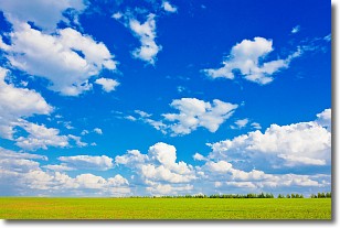
Weather Topic: What are Cumulus Clouds?
Home - Education - Cloud Types - Cumulus Clouds
 Next Topic: Drizzle
Cumulus clouds are fluffy and textured with rounded tops, and
may have flat bottoms. The border of a cumulus cloud
is clearly defined, and can have the appearance of cotton or cauliflower.
Cumulus clouds form at low altitudes (rarely above 2 km) but can grow very tall,
becoming cumulus congestus and possibly the even taller cumulonimbus clouds.
When cumulus clouds become taller, they have a greater chance of producing precipitation.
Next Topic: Drizzle
Weather Topic: What is Evaporation?
Home - Education - Precipitation - Evaporation
 Next Topic: Fog
Evaporation is the process which returns water from the earth
back to the atmosphere, and is another crucial process in the water cycle.
Evaporation is the transformation of liquid into gas, and it happens because
molecules are excited by the application of energy and turn into vapor.
In order for water to evaporate it has to be on the surface of a body of water.
Next Topic: Fog
Current conditions powered by WeatherAPI.com


