Weather Alert in Kansas
Severe Thunderstorm Watch issued September 3 at 7:00PM CDT until September 3 at 11:00PM CDT by NWS Wichita KS
AREAS AFFECTED: Allen, KS; Butler, KS; Chase, KS; Chautauqua, KS; Cowley, KS; Elk, KS; Greenwood, KS; Harper, KS; Harvey, KS; Kingman, KS; Labette, KS; McPherson, KS; Marion, KS; Montgomery, KS; Neosho, KS; Reno, KS; Rice, KS; Sedgwick, KS; Sumner, KS; Wilson, KS; Woodson, KS
DESCRIPTION: SEVERE THUNDERSTORM WATCH 605 REMAINS VALID UNTIL 11 PM CDT THIS EVENING FOR THE FOLLOWING AREAS IN KANSAS THIS WATCH INCLUDES 21 COUNTIES IN CENTRAL KANSAS CHASE MARION MCPHERSON RICE IN SOUTH CENTRAL KANSAS BUTLER COWLEY HARPER HARVEY KINGMAN RENO SEDGWICK SUMNER IN SOUTHEAST KANSAS ALLEN CHAUTAUQUA ELK GREENWOOD LABETTE MONTGOMERY NEOSHO WILSON WOODSON THIS INCLUDES THE CITIES OF ANDOVER, ANTHONY, ARKANSAS CITY, ATTICA, AUGUSTA, BEL AIRE, CEDAR VALE, CHANUTE, COFFEYVILLE, COTTONWOOD FALLS, DERBY, EL DORADO, EUREKA, FREDONIA, GRENOLA, HARPER, HAYSVILLE, HILLSBORO, HOWARD, HUMBOLDT, HUTCHINSON, INDEPENDENCE, IOLA, KINGMAN, LONGTON, LYONS, MADISON, MARION, MCPHERSON, MOLINE, NEODESHA, NEWTON, PARK CITY, PARSONS, PEABODY, ROSE HILL, SEDAN, STERLING, STRONG CITY, VALLEY CENTER, WELLINGTON, WICHITA, WINFIELD, AND YATES CENTER.
INSTRUCTION: N/A
Want more detail? Get the Complete 7 Day and Night Detailed Forecast!
Current U.S. National Radar--Current
The Current National Weather Radar is shown below with a UTC Time (subtract 5 hours from UTC to get Eastern Time).

National Weather Forecast--Current
The Current National Weather Forecast and National Weather Map are shown below.

National Weather Forecast for Tomorrow
Tomorrow National Weather Forecast and Tomorrow National Weather Map are show below.

North America Water Vapor (Moisture)
This map shows recent moisture content over North America. Bright and colored areas show high moisture (ie, clouds); brown indicates very little moisture present; black indicates no moisture.

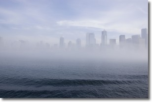
Weather Topic: What is Fog?
Home - Education - Cloud Types - Fog
 Next Topic: Fractus Clouds
Fog is technically a type of stratus cloud, which lies along the
ground and obscures visibility.
It is usually created when humidity in the air condenses into tiny water droplets.
Because of this, some places are more prone to foggy weather, such as regions
close to a body of water.
Fog is similar to mist; both are the appearance of water droplets suspended in
the air, but fog is the term applied to the condition when visibility is less than 1 km.
Next Topic: Fractus Clouds
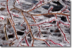
Weather Topic: What is Freezing Rain?
Home - Education - Precipitation - Freezing Rain
 Next Topic: Graupel
Freezing rain is a condition where precipitation which has fallen in the form of
water droplets reaches temperatures which are below freezing and freezes upon
coming into contact
with surface objects. The result of this precipitation is a glaze of ice which
can be damaging to plants and man-made structures. A severe onset of freezing
rain which results in a very thick glaze of ice is known as an ice storm.
Next Topic: Graupel
Current conditions powered by WeatherAPI.com


