Weather Alert in Alaska
Winter Weather Advisory issued March 26 at 3:13PM AKDT until March 28 at 10:00AM AKDT by NWS Juneau AK
AREAS AFFECTED: Annette Island
DESCRIPTION: ...LOW CONTINUES TO SEND BANDS OF SNOW SHOWERS INTO THE SOUTHERN PANHANDLE... A low pressure system over the southern gulf continues to send several waves of snow and rain/snow mix into the southern panhandle. Bands of hit-or-miss snow showers. Total snow accumulations will be highly dependent on temperatures. Afternoon temperatures could reach the mid to upper 30s, especially near the coast, possibly limiting overall snow accumulation. Further inland, areas could stay colder and receive higher amounts. * WHAT...Snow. Additional snow accumulations of 6 to 11 inches. Winds gusting as high as 35 mph. * WHERE...Annette Island. * WHEN...Until 10 AM AKDT Saturday. * IMPACTS...Travel could be very difficult. * ADDITIONAL DETAILS...Total snow accumulations will be highly dependent on daytime temperatures. Afternoon temperatures will reach the mid to upper 30s limiting snow accumulation but inland areas could stay colder, and hit-or-miss snow showers will result in highly variable snow accumulations across Annette Island. Times of moderate snow can quickly reduce visibilities to below 1 mile. Snow showers diminish through the weekend.
INSTRUCTION: Slow down and use caution while traveling. People are urged to prepare their property before the onset of winter weather. For the latest road conditions, where available, call 5 1 1 or visit 511.alaska.gov.
Want more detail? Get the Complete 7 Day and Night Detailed Forecast!
Current U.S. National Radar--Current
The Current National Weather Radar is shown below with a UTC Time (subtract 5 hours from UTC to get Eastern Time).

National Weather Forecast--Current
The Current National Weather Forecast and National Weather Map are shown below.

National Weather Forecast for Tomorrow
Tomorrow National Weather Forecast and Tomorrow National Weather Map are show below.

North America Water Vapor (Moisture)
This map shows recent moisture content over North America. Bright and colored areas show high moisture (ie, clouds); brown indicates very little moisture present; black indicates no moisture.

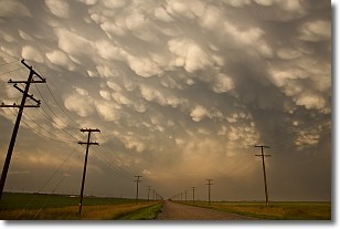
Weather Topic: What are Mammatus Clouds?
Home - Education - Cloud Types - Mammatus Clouds
 Next Topic: Nimbostratus Clouds
A mammatus cloud is a cloud with a unique feature which resembles
a web of pouches hanging along the base of the cloud.
In the United States, mammatus clouds tend to form in the warmer months, commonly
in the Midwest and eastern regions.
While they usually form at the bottom of a cumulonimbis cloud, they can also form
under altostratus, altocumulus, stratocumulus, and cirrus clouds. Mammatus clouds
warn that severe weather is close.
Next Topic: Nimbostratus Clouds
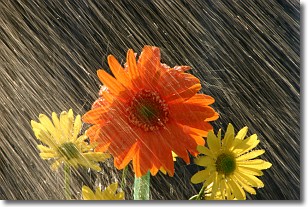
Weather Topic: What is Precipitation?
Home - Education - Precipitation - Precipitation
 Next Topic: Rain
Precipitation can refer to many different forms of water that
may fall from clouds. Precipitation occurs after a cloud has become saturated to
the point where its water particles are more dense than the air below the cloud.
In most cases, precipitation will reach the ground, but it is not uncommon for
precipitation to evaporate before it reaches the earth's surface.
When precipitation evaporates before it contacts the ground it is called Virga.
Graupel, hail, sleet, rain, drizzle, and snow are forms of precipitation, but fog
and mist are not considered precipitation because the water vapor which
constitutes them isn't dense enough to fall to the ground.
Next Topic: Rain
Current conditions powered by WeatherAPI.com


