Weather Alert in Idaho
Air Stagnation Advisory issued February 7 at 12:22PM MST until February 8 at 10:00AM MST by NWS Boise ID
AREAS AFFECTED: Lower Treasure Valley; Upper Treasure Valley; Western Magic Valley; Upper Weiser River; Oregon Lower Treasure Valley
DESCRIPTION: * WHAT...High pressure aloft with light surface winds and little vertical mixing will continue the period of stagnant air through tomorrow morning. This is due to an inversion near the surface that will continue to trap pollutants. * WHERE...Portions of south central and southwest Idaho and southeast Oregon. * WHEN...Until 10 AM MST /9 AM PST/ Sunday. * IMPACTS...Poor air quality may cause issues for people with respiratory problems.
INSTRUCTION: Persons with respiratory illness should follow their physicians advice for dealing with high levels of air pollution during periods of stagnant air.
Want more detail? Get the Complete 7 Day and Night Detailed Forecast!
Current U.S. National Radar--Current
The Current National Weather Radar is shown below with a UTC Time (subtract 5 hours from UTC to get Eastern Time).

National Weather Forecast--Current
The Current National Weather Forecast and National Weather Map are shown below.

National Weather Forecast for Tomorrow
Tomorrow National Weather Forecast and Tomorrow National Weather Map are show below.

North America Water Vapor (Moisture)
This map shows recent moisture content over North America. Bright and colored areas show high moisture (ie, clouds); brown indicates very little moisture present; black indicates no moisture.

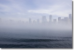
Weather Topic: What is Fog?
Home - Education - Cloud Types - Fog
 Next Topic: Fractus Clouds
Fog is technically a type of stratus cloud, which lies along the
ground and obscures visibility.
It is usually created when humidity in the air condenses into tiny water droplets.
Because of this, some places are more prone to foggy weather, such as regions
close to a body of water.
Fog is similar to mist; both are the appearance of water droplets suspended in
the air, but fog is the term applied to the condition when visibility is less than 1 km.
Next Topic: Fractus Clouds
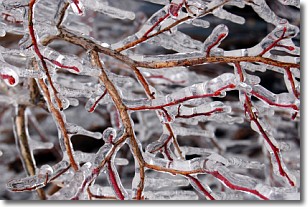
Weather Topic: What is Freezing Rain?
Home - Education - Precipitation - Freezing Rain
 Next Topic: Graupel
Freezing rain is a condition where precipitation which has fallen in the form of
water droplets reaches temperatures which are below freezing and freezes upon
coming into contact
with surface objects. The result of this precipitation is a glaze of ice which
can be damaging to plants and man-made structures. A severe onset of freezing
rain which results in a very thick glaze of ice is known as an ice storm.
Next Topic: Graupel
Current conditions powered by WeatherAPI.com


