Weather Alert in Hawaii
High Wind Warning issued February 7 at 3:48PM HST until February 9 at 6:00PM HST by NWS Honolulu HI
AREAS AFFECTED: Kauai Southwest; Kauai Mountains; Waianae Coast; Central Oahu; Waianae Mountains; Lanai Mauka; Kahoolawe; Maui Leeward West; Kohala; Big Island Interior; Kauai South; Honolulu Metro; Ewa Plain; Koolau Leeward; Molokai West; Molokai Leeward South; Lanai Windward; Lanai Leeward; Lanai South; Maui Central Valley North; Maui Central Valley South
DESCRIPTION: * WHAT...East winds 20 to 30 mph with gusts to 50 mph in the morning strengthening to 25 to 35 mph with gusts to 60 mph by late afternoon into the evening. * WHERE...Kauai, Maui, Molokai, Niihau, Oahu, and portions of the Big Island. Areas most at risk include higher terrain, passes, and areas immediately south and west of mountains. * WHEN...From 6 AM Sunday to 6 PM HST Monday. * IMPACTS...Damaging winds may blow down trees and power lines and damage roofs. Power outages are possible. Travel will be difficult, especially for high profile vehicles.
INSTRUCTION: Strong winds may lead to property damage. Hazardous driving conditions due to powerful cross winds will pose a serious risk for drivers, especially for light weight and high profile vehicles. Loose outdoor items should be brought inside or secured properly. A High Wind Warning means that winds are expected to be at least 40 mph, with gusts over 60 mph. Stay away from downed power lines.
Want more detail? Get the Complete 7 Day and Night Detailed Forecast!
Current U.S. National Radar--Current
The Current National Weather Radar is shown below with a UTC Time (subtract 5 hours from UTC to get Eastern Time).

National Weather Forecast--Current
The Current National Weather Forecast and National Weather Map are shown below.

National Weather Forecast for Tomorrow
Tomorrow National Weather Forecast and Tomorrow National Weather Map are show below.

North America Water Vapor (Moisture)
This map shows recent moisture content over North America. Bright and colored areas show high moisture (ie, clouds); brown indicates very little moisture present; black indicates no moisture.

Weather Topic: What is Freezing Rain?
Home - Education - Precipitation - Freezing Rain
 Next Topic: Graupel
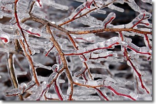
Freezing rain is a condition where precipitation which has fallen in the form of
water droplets reaches temperatures which are below freezing and freezes upon
coming into contact
with surface objects. The result of this precipitation is a glaze of ice which
can be damaging to plants and man-made structures. A severe onset of freezing
rain which results in a very thick glaze of ice is known as an ice storm.
Next Topic: Graupel
Weather Topic: What is Hail?
Home - Education - Precipitation - Hail
 Next Topic: Hole Punch Clouds
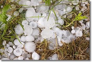
Hail is a form of precipitation which is recognized by large solid balls or
clumps of ice. Hail is created by thunderstorm clouds with strong updrafts of wind.
As the hailstones remain in the updraft, ice is deposited onto them until their
weight becomes heavy enough for them to fall to the earth's surface.
Hail storms can cause significant damage to crops, aircrafts, and man-made structures,
despite the fact that the duration is usually less than ten minutes.
Next Topic: Hole Punch Clouds
Current conditions powered by WeatherAPI.com


