Weather Alert in North Carolina
Beach Hazards Statement issued August 21 at 11:10PM EDT until August 22 at 8:00PM EDT by NWS Newport/Morehead City NC
AREAS AFFECTED: Ocracoke Island
DESCRIPTION: * WHAT...For the Coastal Flood Advisory, one to two feet of inundation above ground level in low-lying areas near shorelines and tidal waterways. For the Beach Hazards Statement, dangerous rip currents. * WHERE...Ocracoke Island. * WHEN...For the Coastal Flood Advisory, until midnight EDT Friday night. For the Beach Hazards Statement, from 7 AM EDT Friday through Friday evening. * IMPACTS...Up to 1 to 2 feet of inundation above ground level is possible in low-lying areas soundside near shorelines and tidal waterways resulting in a low threat of property damage. In areas of compromised dune structures some additional ocean overwash is possible around high tide Friday morning and Friday evening, which could lead to locally higher inundation. Some roads and low lying property including parking lots, parks, lawns, and homes adjacent to the waterfront will experience shallow flooding. Rip currents can sweep even the best swimmers away from shore into deeper water. * ADDITIONAL DETAILS...The most likely time for strong rip currents to occur is a couple hours either side of low tide, which will occur around 1:30 pm Friday.
INSTRUCTION: If travel is required, allow extra time as some roads may be closed. Do not drive around barricades or through water of unknown depth. Take the necessary actions to protect flood-prone property. Life-threatening rip currents. If caught in a rip current, remain calm. Swim in a direction following the shoreline. If tired, float or tread water until out of the rip current. If unable to escape, face the shore and call or wave for help.
Want more detail? Get the Complete 7 Day and Night Detailed Forecast!
Current U.S. National Radar--Current
The Current National Weather Radar is shown below with a UTC Time (subtract 5 hours from UTC to get Eastern Time).

National Weather Forecast--Current
The Current National Weather Forecast and National Weather Map are shown below.

National Weather Forecast for Tomorrow
Tomorrow National Weather Forecast and Tomorrow National Weather Map are show below.

North America Water Vapor (Moisture)
This map shows recent moisture content over North America. Bright and colored areas show high moisture (ie, clouds); brown indicates very little moisture present; black indicates no moisture.

Weather Topic: What are Altostratus Clouds?
Home - Education - Cloud Types - Altostratus Clouds
 Next Topic: Cirrocumulus Clouds
Altostratus clouds form at mid to high-level altitudes
(between 2 and 7 km) and are created by a warm, stable air mass which causes
water vapor
to condense as it rise through the atmosphere. Usually altostratus clouds are
featureless sheets characterized by a uniform color.
In some cases, wind punching through the cloud formation may give it a waved
appearance, called altostratus undulatus. Altostratus clouds
are commonly seen with other cloud formations accompanying them.
Next Topic: Cirrocumulus Clouds
Weather Topic: What are Cirrostratus Clouds?
Home - Education - Cloud Types - Cirrostratus Clouds
 Next Topic: Cirrus Clouds
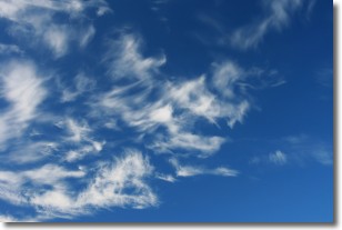
Cirrostratus clouds are high, thin clouds that form above
20,000 feet and are made mostly of ice crystals. They sometimes look like giant
feathers, horse tails, or curls of hair in the sky.
These clouds are pushed by the jet stream and can move at high speeds reaching
100 mph.
What do they indicate?
They indicate that a precipitation is likely within 24 hours.
Next Topic: Cirrus Clouds
Current conditions powered by WeatherAPI.com


