Weather Alert in Minnesota
Fire Weather Watch issued March 26 at 1:43PM CDT until March 28 at 7:00PM CDT by NWS Twin Cities/Chanhassen MN
AREAS AFFECTED: Douglas; Todd; Morrison; Mille Lacs; Kanabec; Stevens; Pope; Stearns; Benton; Sherburne; Isanti; Chisago; Swift; Chippewa; Kandiyohi; Meeker; Wright; Hennepin; Anoka; Ramsey; Washington; Renville; McLeod; Sibley; Carver; Scott; Dakota; Nicollet; Le Sueur; Rice; Goodhue; Waseca; Steele; Freeborn
DESCRIPTION: ...CRITICAL FIRE WEATHER CONDITIONS POSSIBLE SATURDAY... .The combination of warmer temperatures near 60, very low relative humidity values between 15 to 20 percent, southwest winds gusting to 35 to 45 mph, and dry fuels may lead to critical fire weather conditions across central and southern Minnesota on Saturday. The National Weather Service in the Twin Cities has issued a Fire Weather Watch. * AFFECTED AREA...Portions of central, east central, south central, southeast, and west central Minnesota. * TIMING...From Saturday afternoon through Saturday evening. * WINDS...Southwest winds 20 to 30 mph with gusts up to 40 mph. * RELATIVE HUMIDITY...As low as 18 percent. * IMPACTS...Any fires that develop will spread rapidly. Outdoor burning is not recommended.
INSTRUCTION: Please advise the appropriate officials or fire crews in the field of this Fire Weather Watch.
Want more detail? Get the Complete 7 Day and Night Detailed Forecast!
Current U.S. National Radar--Current
The Current National Weather Radar is shown below with a UTC Time (subtract 5 hours from UTC to get Eastern Time).

National Weather Forecast--Current
The Current National Weather Forecast and National Weather Map are shown below.

National Weather Forecast for Tomorrow
Tomorrow National Weather Forecast and Tomorrow National Weather Map are show below.

North America Water Vapor (Moisture)
This map shows recent moisture content over North America. Bright and colored areas show high moisture (ie, clouds); brown indicates very little moisture present; black indicates no moisture.

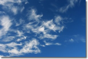
Weather Topic: What are Altostratus Clouds?
Home - Education - Cloud Types - Altostratus Clouds
 Next Topic: Cirrocumulus Clouds
Altostratus clouds form at mid to high-level altitudes
(between 2 and 7 km) and are created by a warm, stable air mass which causes
water vapor
to condense as it rise through the atmosphere. Usually altostratus clouds are
featureless sheets characterized by a uniform color.
In some cases, wind punching through the cloud formation may give it a waved
appearance, called altostratus undulatus. Altostratus clouds
are commonly seen with other cloud formations accompanying them.
Next Topic: Cirrocumulus Clouds
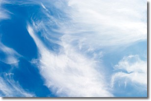
Weather Topic: What are Cirrostratus Clouds?
Home - Education - Cloud Types - Cirrostratus Clouds
 Next Topic: Cirrus Clouds
Cirrostratus clouds are high, thin clouds that form above
20,000 feet and are made mostly of ice crystals. They sometimes look like giant
feathers, horse tails, or curls of hair in the sky.
These clouds are pushed by the jet stream and can move at high speeds reaching
100 mph.
What do they indicate?
They indicate that a precipitation is likely within 24 hours.
Next Topic: Cirrus Clouds
Current conditions powered by WeatherAPI.com


