Weather Alert in Minnesota
Fire Weather Watch issued March 26 at 1:43PM CDT until March 28 at 7:00PM CDT by NWS Twin Cities/Chanhassen MN
AREAS AFFECTED: Douglas; Todd; Morrison; Mille Lacs; Kanabec; Stevens; Pope; Stearns; Benton; Sherburne; Isanti; Chisago; Swift; Chippewa; Kandiyohi; Meeker; Wright; Hennepin; Anoka; Ramsey; Washington; Renville; McLeod; Sibley; Carver; Scott; Dakota; Nicollet; Le Sueur; Rice; Goodhue; Waseca; Steele; Freeborn
DESCRIPTION: ...CRITICAL FIRE WEATHER CONDITIONS POSSIBLE SATURDAY... .The combination of warmer temperatures near 60, very low relative humidity values between 15 to 20 percent, southwest winds gusting to 35 to 45 mph, and dry fuels may lead to critical fire weather conditions across central and southern Minnesota on Saturday. The National Weather Service in the Twin Cities has issued a Fire Weather Watch. * AFFECTED AREA...Portions of central, east central, south central, southeast, and west central Minnesota. * TIMING...From Saturday afternoon through Saturday evening. * WINDS...Southwest winds 20 to 30 mph with gusts up to 40 mph. * RELATIVE HUMIDITY...As low as 18 percent. * IMPACTS...Any fires that develop will spread rapidly. Outdoor burning is not recommended.
INSTRUCTION: Please advise the appropriate officials or fire crews in the field of this Fire Weather Watch.
Want more detail? Get the Complete 7 Day and Night Detailed Forecast!
Current U.S. National Radar--Current
The Current National Weather Radar is shown below with a UTC Time (subtract 5 hours from UTC to get Eastern Time).

National Weather Forecast--Current
The Current National Weather Forecast and National Weather Map are shown below.

National Weather Forecast for Tomorrow
Tomorrow National Weather Forecast and Tomorrow National Weather Map are show below.

North America Water Vapor (Moisture)
This map shows recent moisture content over North America. Bright and colored areas show high moisture (ie, clouds); brown indicates very little moisture present; black indicates no moisture.

Weather Topic: What is Freezing Rain?
Home - Education - Precipitation - Freezing Rain
 Next Topic: Graupel
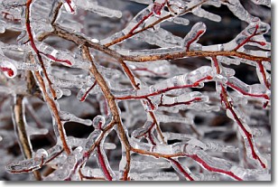
Freezing rain is a condition where precipitation which has fallen in the form of
water droplets reaches temperatures which are below freezing and freezes upon
coming into contact
with surface objects. The result of this precipitation is a glaze of ice which
can be damaging to plants and man-made structures. A severe onset of freezing
rain which results in a very thick glaze of ice is known as an ice storm.
Next Topic: Graupel
Weather Topic: What is Hail?
Home - Education - Precipitation - Hail
 Next Topic: Hole Punch Clouds
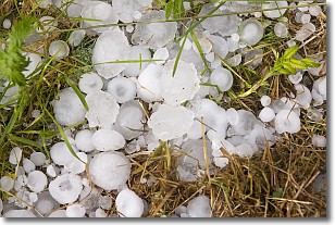
Hail is a form of precipitation which is recognized by large solid balls or
clumps of ice. Hail is created by thunderstorm clouds with strong updrafts of wind.
As the hailstones remain in the updraft, ice is deposited onto them until their
weight becomes heavy enough for them to fall to the earth's surface.
Hail storms can cause significant damage to crops, aircrafts, and man-made structures,
despite the fact that the duration is usually less than ten minutes.
Next Topic: Hole Punch Clouds
Current conditions powered by WeatherAPI.com


