Weather Alert in Alabama
Fire Weather Watch issued March 26 at 1:47PM CDT until March 28 at 7:00PM CDT by NWS Huntsville AL
AREAS AFFECTED: Lauderdale; Colbert; Franklin; Lawrence; Limestone; Madison; Morgan; Marshall; Jackson; DeKalb; Winston; Cullman
DESCRIPTION: ...Fire Weather Watch in Effect Saturday 7 AM until 7 PM For All of North Alabama... The National Weather Service in Huntsville has issued a Fire Weather Watch for north Alabama, which is in effect from Saturday morning through Saturday evening. * AFFECTED AREA...Fire Weather Zone 001 Lauderdale, Fire Weather Zone 002 Colbert, Fire Weather Zone 003 Franklin AL, Fire Weather Zone 004 Lawrence, Fire Weather Zone 005 Limestone, Fire Weather Zone 006 Madison, Fire Weather Zone 007 Morgan, Fire Weather Zone 008 Marshall, Fire Weather Zone 009 Jackson, Fire Weather Zone 010 DeKalb, Fire Weather Zone 014 Winston and Fire Weather Zone 016 Cullman. * WINDS...Northeast 10 to 15 mph with gusts up to 30 mph. * RELATIVE HUMIDITY...As low as 23 percent. * IMPACTS...Any fires that develop will likely spread rapidly. Please obey any local burn bans that are in place!
INSTRUCTION: A Fire Weather Watch means that critical fire weather conditions are forecast to occur. Listen for later forecasts and possible Red Flag Warnings.
Want more detail? Get the Complete 7 Day and Night Detailed Forecast!
Current U.S. National Radar--Current
The Current National Weather Radar is shown below with a UTC Time (subtract 5 hours from UTC to get Eastern Time).

National Weather Forecast--Current
The Current National Weather Forecast and National Weather Map are shown below.

National Weather Forecast for Tomorrow
Tomorrow National Weather Forecast and Tomorrow National Weather Map are show below.

North America Water Vapor (Moisture)
This map shows recent moisture content over North America. Bright and colored areas show high moisture (ie, clouds); brown indicates very little moisture present; black indicates no moisture.

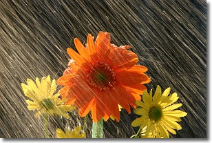
Weather Topic: What is Rain?
Home - Education - Precipitation - Rain
 Next Topic: Shelf Clouds
Precipitation in the form of water droplets is called rain.
Rain generally has a tendency to fall with less intensity over a greater period
of time, and when rainfall is more severe it is usually less sustained.
Rain is the most common form of precipitation and happens with greater frequency
depending on the season and regional influences. Cities have been shown to have
an observable effect on rainfall, due to an effect called the urban heat island.
Compared to upwind, monthly rainfall between twenty and forty miles downwind of
cities is 30% greater.
Next Topic: Shelf Clouds
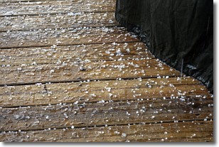
Weather Topic: What is Sleet?
Home - Education - Precipitation - Sleet
 Next Topic: Snow
Sleet is a form of precipitation in which small ice pellets are the primary
components. These ice pellets are smaller and more translucent than hailstones,
and harder than graupel. Sleet is caused by specific atmospheric conditions and
therefore typically doesn't last for extended periods of time.
The condition which leads to sleet formation requires a warmer body of air to be
wedged in between two sub-freezing bodies of air. When snow falls through a warmer
layer of air it melts, and as it falls through the next sub-freezing body of air
it freezes again, forming ice pellets known as sleet. In some cases, water
droplets don't have time to freeze before reaching the surface and the result is
freezing rain.
Next Topic: Snow
Current conditions powered by WeatherAPI.com


