Weather Alert in New York
Flood Warning issued March 27 at 1:57AM EDT until March 27 at 8:00PM EDT by NWS Buffalo NY
AREAS AFFECTED: Monroe, NY
DESCRIPTION: * WHAT...Small stream flooding along Irondequoit Creek caused by heavy rainfall is expected. * WHERE...A portion of western New York, including the following county, Monroe. * WHEN...Until 800 PM EDT Friday. * IMPACTS...Flooding will continue today along Irondequoit Creek in the eastern suburbs of Rochester. Expect flooding of low lying areas in Ellison Park. High water may approach Blossom Road where it passes through Ellison Park. * ADDITIONAL DETAILS... - At 151 AM EDT, Gauge reports indicated high water levels along Irondequoit Creek, with levels continuing to rise early this morning. Between 0.75 and 1.25 inches of rain have fallen. - Flooding impacts will continue, but no additional rainfall is expected. - Some locations that will experience flooding include... Areas along Irondequoit Creek in Irondequoit, East Rochester, Fairport, Brighton and Penfield. - http://www.weather.gov/safety/flood
INSTRUCTION: Turn around, don't drown when encountering flooded roads. Most flood deaths occur in vehicles. Keep children away from storm drains, culverts, creeks and streams. Water levels can rise rapidly and sweep children away. Flooding is occurring or is imminent. It is important to know where you are relative to streams, rivers, or creeks which can become killers in heavy rains. Hikers should avoid streams or creeks.
Want more detail? Get the Complete 7 Day and Night Detailed Forecast!
Current U.S. National Radar--Current
The Current National Weather Radar is shown below with a UTC Time (subtract 5 hours from UTC to get Eastern Time).

National Weather Forecast--Current
The Current National Weather Forecast and National Weather Map are shown below.

National Weather Forecast for Tomorrow
Tomorrow National Weather Forecast and Tomorrow National Weather Map are show below.

North America Water Vapor (Moisture)
This map shows recent moisture content over North America. Bright and colored areas show high moisture (ie, clouds); brown indicates very little moisture present; black indicates no moisture.

Weather Topic: What is Condensation?
Home - Education - Precipitation - Condensation
 Next Topic: Contrails
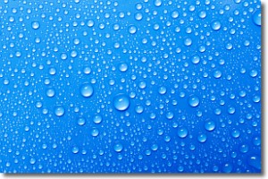
Condensation is the process which creates clouds, and therefore
it is a crucial process in the water cycle.
Condensation is the change of matter from a state of gas into a state of liquid,
and it happens because water molecules release heat into the atmosphere and
become organized into a more closely packed structure, what we might see as
water droplets.
Water is always present in the air around us as a vapor, but it's too small for
us to see. When water undergoes the process of condensation it becomes organized
into visible water droplets. You've probably seen condensation happen before on the
surface of a cold drink!
Next Topic: Contrails
Weather Topic: What are Cumulonimbus Clouds?
Home - Education - Cloud Types - Cumulonimbus Clouds
 Next Topic: Cumulus Clouds
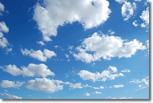
The final form taken by a growing cumulus cloud is the
cumulonimbus cloud, which is very tall and dense.
The tower of a cumulonimbus cloud can soar 23 km into the atmosphere, although
most commonly they stop growing at an altitude of 6 km.
Even small cumulonimbus clouds appear very large in comparison to other cloud types.
They can signal the approach of stormy weather, such as thunderstorms or blizzards.
Next Topic: Cumulus Clouds
Current conditions powered by WeatherAPI.com


