Weather Alert in Alaska
Flood Watch issued September 2 at 7:41AM AKDT until September 7 at 10:00AM AKDT by NWS Anchorage AK
AREAS AFFECTED: NW Kenai Peninsula; Skilak Lake
DESCRIPTION: * WHAT...Flooding caused by the Skilak glacier-dammed lake release is possible. * WHERE...Skilak Lake and the Middle Kenai River near Skilak Lake and the Kenai River Downstream of Skilak Lake. * WHEN...Through Sunday morning. * IMPACTS...Kenai River level forecasts: Currently expecting the Kenai River to rise steadily at Skilak Lake outlet another 2 feet, cresting at moderate flood stage Friday or Saturday. At the Kenai Keys, expecting the Kenai River to rise another 2 to 2.5 feet, cresting just below moderate flood stage of 12 feet Friday or Saturday. Down river at Soldotna, expecting the Kenai River to rise steadily through week, cresting Saturday above bankfull levels near 12 feet. IMPACTS: Expect steady river level increases next 4 days on lower Kenai River. Flooding of low lying areas in the Kenai Keys area, boat dock issues and extended period of high water and bankfull conditions is likely. Excessive runoff may result in flooding of rivers, creeks, streams, and other low-lying and flood-prone locations. * ADDITIONAL DETAILS... - Skilak Glacier Dam Lake is likely releasing. This combined with recent significant rain in the upper Kenai River basin will cause Kenai river levels to rise steadily from the outlet of Skilak Lake to the mouth through the end of this week. Some uncertainty exists due to recent rain as to when the Skilak Glacier Dam lake began releasing which could impact the crest timing and height. Planned aerial reconnaissance of Skilak Glacier Dam Lake will confirm whether a release has taken place and the extent of any release. - Http://www.weather.gov/safety/flood
INSTRUCTION: You should monitor later forecasts and be alert for possible Flood Warnings. Those living in areas prone to flooding should be prepared to take action should flooding develop. Stay tuned to further developments by listening to your local radio, television, or NOAA Weather Radio for further information.
Want more detail? Get the Complete 7 Day and Night Detailed Forecast!
Current U.S. National Radar--Current
The Current National Weather Radar is shown below with a UTC Time (subtract 5 hours from UTC to get Eastern Time).

National Weather Forecast--Current
The Current National Weather Forecast and National Weather Map are shown below.

National Weather Forecast for Tomorrow
Tomorrow National Weather Forecast and Tomorrow National Weather Map are show below.

North America Water Vapor (Moisture)
This map shows recent moisture content over North America. Bright and colored areas show high moisture (ie, clouds); brown indicates very little moisture present; black indicates no moisture.

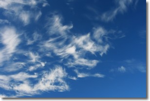
Weather Topic: What are Cirrostratus Clouds?
Home - Education - Cloud Types - Cirrostratus Clouds
 Next Topic: Cirrus Clouds
Cirrostratus clouds are high, thin clouds that form above
20,000 feet and are made mostly of ice crystals. They sometimes look like giant
feathers, horse tails, or curls of hair in the sky.
These clouds are pushed by the jet stream and can move at high speeds reaching
100 mph.
What do they indicate?
They indicate that a precipitation is likely within 24 hours.
Next Topic: Cirrus Clouds
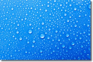
Weather Topic: What is Condensation?
Home - Education - Precipitation - Condensation
 Next Topic: Contrails
Condensation is the process which creates clouds, and therefore
it is a crucial process in the water cycle.
Condensation is the change of matter from a state of gas into a state of liquid,
and it happens because water molecules release heat into the atmosphere and
become organized into a more closely packed structure, what we might see as
water droplets.
Water is always present in the air around us as a vapor, but it's too small for
us to see. When water undergoes the process of condensation it becomes organized
into visible water droplets. You've probably seen condensation happen before on the
surface of a cold drink!
Next Topic: Contrails
Current conditions powered by WeatherAPI.com


