Weather Alert in Connecticut
Special Weather Statement issued September 6 at 4:19AM EDT by NWS Boston/Norton MA
AREAS AFFECTED: Hartford; Tolland; Windham; Western Franklin; Eastern Franklin; Northern Worcester; Western Hampshire; Western Hampden; Eastern Hampshire; Eastern Hampden; Southern Worcester; Northwest Middlesex County
DESCRIPTION: A cold front brings potential for scattered severe thunderstorms today to interior southern New England. Thunderstorms may begin to pop-up across eastern New York, along the border with Connecticut and Massachusetts early as 12-2pm. There after is prime time for storms to build develop,between 2-6pm, across the interior of southern New England. Expect thunderstorms to weaken as the line shifts to the I-95 corridor between 7-10pm. Thunderstorms will have the potential to produce straight-line damaging winds, hail, localized flash flooding in urban areas or locations of poor drainage, frequent lightning, and a lower risk of tornadoes. Whether you are heading to an outdoor event or hanging around the house, today is one of those days to remain weather aware, and have multiple ways of receiving weather alerts (cell phone notifications, NOAA Weather Radio, and broadcast meteorologists).
INSTRUCTION: N/A
Want more detail? Get the Complete 7 Day and Night Detailed Forecast!
Current U.S. National Radar--Current
The Current National Weather Radar is shown below with a UTC Time (subtract 5 hours from UTC to get Eastern Time).

National Weather Forecast--Current
The Current National Weather Forecast and National Weather Map are shown below.

National Weather Forecast for Tomorrow
Tomorrow National Weather Forecast and Tomorrow National Weather Map are show below.

North America Water Vapor (Moisture)
This map shows recent moisture content over North America. Bright and colored areas show high moisture (ie, clouds); brown indicates very little moisture present; black indicates no moisture.

Weather Topic: What is Hail?
Home - Education - Precipitation - Hail
 Next Topic: Hole Punch Clouds
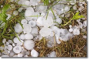
Hail is a form of precipitation which is recognized by large solid balls or
clumps of ice. Hail is created by thunderstorm clouds with strong updrafts of wind.
As the hailstones remain in the updraft, ice is deposited onto them until their
weight becomes heavy enough for them to fall to the earth's surface.
Hail storms can cause significant damage to crops, aircrafts, and man-made structures,
despite the fact that the duration is usually less than ten minutes.
Next Topic: Hole Punch Clouds
Weather Topic: What are Mammatus Clouds?
Home - Education - Cloud Types - Mammatus Clouds
 Next Topic: Nimbostratus Clouds
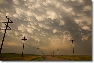
A mammatus cloud is a cloud with a unique feature which resembles
a web of pouches hanging along the base of the cloud.
In the United States, mammatus clouds tend to form in the warmer months, commonly
in the Midwest and eastern regions.
While they usually form at the bottom of a cumulonimbis cloud, they can also form
under altostratus, altocumulus, stratocumulus, and cirrus clouds. Mammatus clouds
warn that severe weather is close.
Next Topic: Nimbostratus Clouds
Current conditions powered by WeatherAPI.com


