Weather Alert in Kentucky
Special Weather Statement issued February 7 at 2:25PM EST by NWS Louisville KY
AREAS AFFECTED: Franklin; Scott; Harrison; Woodford; Fayette; Bourbon; Nicholas; Clark
DESCRIPTION: The latest forecasts suggest that a narrow band of light snow will impact portions of the Bluegrass region of central Kentucky Sunday morning. The time of light snow appears to favor the 700 am to Noon EST timeframe. Snowfall accumulations of a coating to an inch will be possible. Again, this band will be quite narrow and areas outside this swath will likely see little to no snow. The exact placement of this snowband remains uncertain. Currently, the highest probabilities of an inch of snow are across northeast portions of the Bluegrass region including the counties of Scott, Harrison, Bourbon, and Nicholas. This band could shift a little northeast or southwest and could impact areas as far west as western Woodford and Fayette counties. Those with travel plans Sunday morning are encouraged to monitor the latest forecasts. Be prepared for rapidly changing visibilitiesand potentially slick driving conditions.
INSTRUCTION: N/A
Want more detail? Get the Complete 7 Day and Night Detailed Forecast!
Current U.S. National Radar--Current
The Current National Weather Radar is shown below with a UTC Time (subtract 5 hours from UTC to get Eastern Time).

National Weather Forecast--Current
The Current National Weather Forecast and National Weather Map are shown below.

National Weather Forecast for Tomorrow
Tomorrow National Weather Forecast and Tomorrow National Weather Map are show below.

North America Water Vapor (Moisture)
This map shows recent moisture content over North America. Bright and colored areas show high moisture (ie, clouds); brown indicates very little moisture present; black indicates no moisture.

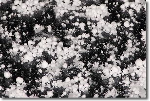
Weather Topic: What is Graupel?
Home - Education - Precipitation - Graupel
 Next Topic: Hail
Graupel is a form of precipitation that is created by atmospheric conditions
which cause supercooled water droplets to contact snow crystals and freeze to
their surface.
Sometimes known as soft hail or snow pellets, graupel is delicate and easily
destroyed by touch. Whereas hail usually falls during severe weather, graupel
doesn't require such conditions to form, and can form in mild precipitation
similar to situations which produce snowfall.
Next Topic: Hail
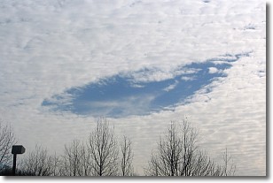
Weather Topic: What are Hole Punch Clouds?
Home - Education - Cloud Types - Hole Punch Clouds
 Next Topic: Mammatus Clouds
A hole punch cloud is an unusual occurrence when a disk-shaped
hole appears in a cirrostratus, cirrocumulus, or altocumulus cloud.
When part of the cloud forms ice crystals, water droplets in the surrounding area
of the cloud evaporate. The effect of this process produces a large elliptical
gap in the cloud. The hole punch cloud formation is rare, but it is not specific
to any geographic area.
Other names which have been used to describe this phenomena include fallstreak hole,
skypunch, and cloud hole.
Next Topic: Mammatus Clouds
Current conditions powered by WeatherAPI.com


