Weather Alert in Kentucky
Special Weather Statement issued February 7 at 2:25PM EST by NWS Louisville KY
AREAS AFFECTED: Franklin; Scott; Harrison; Woodford; Fayette; Bourbon; Nicholas; Clark
DESCRIPTION: The latest forecasts suggest that a narrow band of light snow will impact portions of the Bluegrass region of central Kentucky Sunday morning. The time of light snow appears to favor the 700 am to Noon EST timeframe. Snowfall accumulations of a coating to an inch will be possible. Again, this band will be quite narrow and areas outside this swath will likely see little to no snow. The exact placement of this snowband remains uncertain. Currently, the highest probabilities of an inch of snow are across northeast portions of the Bluegrass region including the counties of Scott, Harrison, Bourbon, and Nicholas. This band could shift a little northeast or southwest and could impact areas as far west as western Woodford and Fayette counties. Those with travel plans Sunday morning are encouraged to monitor the latest forecasts. Be prepared for rapidly changing visibilitiesand potentially slick driving conditions.
INSTRUCTION: N/A
Want more detail? Get the Complete 7 Day and Night Detailed Forecast!
Current U.S. National Radar--Current
The Current National Weather Radar is shown below with a UTC Time (subtract 5 hours from UTC to get Eastern Time).

National Weather Forecast--Current
The Current National Weather Forecast and National Weather Map are shown below.

National Weather Forecast for Tomorrow
Tomorrow National Weather Forecast and Tomorrow National Weather Map are show below.

North America Water Vapor (Moisture)
This map shows recent moisture content over North America. Bright and colored areas show high moisture (ie, clouds); brown indicates very little moisture present; black indicates no moisture.

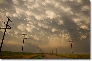
Weather Topic: What are Mammatus Clouds?
Home - Education - Cloud Types - Mammatus Clouds
 Next Topic: Nimbostratus Clouds
A mammatus cloud is a cloud with a unique feature which resembles
a web of pouches hanging along the base of the cloud.
In the United States, mammatus clouds tend to form in the warmer months, commonly
in the Midwest and eastern regions.
While they usually form at the bottom of a cumulonimbis cloud, they can also form
under altostratus, altocumulus, stratocumulus, and cirrus clouds. Mammatus clouds
warn that severe weather is close.
Next Topic: Nimbostratus Clouds
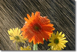
Weather Topic: What is Precipitation?
Home - Education - Precipitation - Precipitation
 Next Topic: Rain
Precipitation can refer to many different forms of water that
may fall from clouds. Precipitation occurs after a cloud has become saturated to
the point where its water particles are more dense than the air below the cloud.
In most cases, precipitation will reach the ground, but it is not uncommon for
precipitation to evaporate before it reaches the earth's surface.
When precipitation evaporates before it contacts the ground it is called Virga.
Graupel, hail, sleet, rain, drizzle, and snow are forms of precipitation, but fog
and mist are not considered precipitation because the water vapor which
constitutes them isn't dense enough to fall to the ground.
Next Topic: Rain
Current conditions powered by WeatherAPI.com


