Weather Alert in Idaho
Air Quality Alert issued August 22 at 2:20PM PDT by NWS Spokane WA
AREAS AFFECTED: Latah, ID; Lewis, ID; Nez Perce, ID
DESCRIPTION: An Air Quality Alert has been issued by the following agencies: Idaho Department of Environmental Quality in Lewiston Nez Perce Tribe ERWM Air Quality Program * WHAT...Air Quality Advisory due to smoke from wildfires. Air Quality Index is forecast to be Unhealthy. * WHERE...Latah and Nez Perce Counties, and the Nez Perce Reservation. * WHEN...Until Monday morning August 25th. * IMPACTS...Those who experience health effects from smoke include children under 18, elders, pregnant women, people with asthma or have difficulty breathing, diabetes, heart problems or otherwise compromised health, and people who have high exposure (those who work, exercise, or spend extensive time outdoors).
INSTRUCTION: Under the most severe pollution level, sensitive groups should avoid outdoor exposure and limit indoor activities, and everyone should restrict their outdoor activities. Idaho Department of Health and Welfare https://healthandwelfare.idaho.gov/health-wellness/environmental- health/idaho-wildfire-and-smoke-information Idaho Smoke Information Hotline: 1-800-345-1007 Idaho DEQ Lewiston Regional Office - (208)-799-4370
Want more detail? Get the Complete 7 Day and Night Detailed Forecast!
Current U.S. National Radar--Current
The Current National Weather Radar is shown below with a UTC Time (subtract 5 hours from UTC to get Eastern Time).

National Weather Forecast--Current
The Current National Weather Forecast and National Weather Map are shown below.

National Weather Forecast for Tomorrow
Tomorrow National Weather Forecast and Tomorrow National Weather Map are show below.

North America Water Vapor (Moisture)
This map shows recent moisture content over North America. Bright and colored areas show high moisture (ie, clouds); brown indicates very little moisture present; black indicates no moisture.

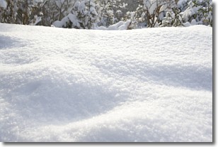
Weather Topic: What is Snow?
Home - Education - Precipitation - Snow
 Next Topic: Stratocumulus Clouds
Snow is precipitation taking the form of ice crystals. Each ice crystal, or snowflake,
has unique characteristics, but all of them grow in a hexagonal structure.
Snowfall can last for sustained periods of time and result in significant buildup
of snow on the ground.
On the earth's surface, snow starts out light and powdery, but as it begins to melt
it tends to become more granular, producing small bits of ice which have the consistency of
sand. After several cycles of melting and freezing, snow can become very dense
and ice-like, commonly known as snow pack.
Next Topic: Stratocumulus Clouds
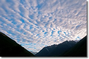
Weather Topic: What are Stratus Clouds?
Home - Education - Cloud Types - Stratus Clouds
 Next Topic: Wall Clouds
Stratus clouds are similar to altostratus clouds, but form at a
lower altitude and are identified by their fog-like appearance, lacking the
distinguishing features of most clouds.
Stratus clouds are wider than most clouds, and their base has a smooth, uniform
look which is lighter in color than a nimbostratus cloud.
The presence of a stratus cloud indicates the possibility of minor precipitation,
such as drizzle, but heavier precipitation does not typically arrive in the form
of a stratus cloud.
Next Topic: Wall Clouds
Current conditions powered by WeatherAPI.com


