Weather Alert in Alaska
Special Weather Statement issued September 7 at 4:04AM AKDT by NWS Anchorage AK
AREAS AFFECTED: Central Aleutians
DESCRIPTION: Ex-typhoon Peipah will lift to the Central Aleutians this evening. There will be two separate peaks of strong winds. One this evening with easterly gusts up to 60 mph at times and the last peak, stronger, Monday morning with northerly gusts around 65 mph at times. A few localized gusts up to 70 mph are possible late Monday morning. There will be a break in strong winds early Monday morning as the low pressure center moves by just to the south and east with northerly winds picking up in earnest on the backside of the system mid-Monday morning. Accompanying the strong winds will be moderate to heavy rain this evening through Monday with rainfall totals 2 inches this evening through Monday night. Winds will significantly decrease starting Monday night and into Tuesday. Residents should secure loose items that can easily be blown around or damaged. Prepare for possible power outages. Travel may be difficult.
INSTRUCTION: N/A
Want more detail? Get the Complete 7 Day and Night Detailed Forecast!
Current U.S. National Radar--Current
The Current National Weather Radar is shown below with a UTC Time (subtract 5 hours from UTC to get Eastern Time).

National Weather Forecast--Current
The Current National Weather Forecast and National Weather Map are shown below.

National Weather Forecast for Tomorrow
Tomorrow National Weather Forecast and Tomorrow National Weather Map are show below.

North America Water Vapor (Moisture)
This map shows recent moisture content over North America. Bright and colored areas show high moisture (ie, clouds); brown indicates very little moisture present; black indicates no moisture.

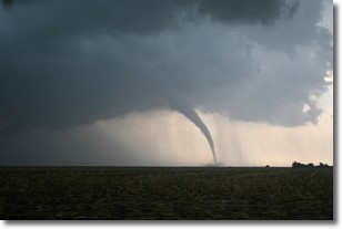
Weather Topic: What are Wall Clouds?
Home - Education - Cloud Types - Wall Clouds
 Next Topic: Altocumulus Clouds
A wall cloud forms underneath the base of a cumulonimbus cloud,
and can be a hotbed for deadly tornadoes.
Wall clouds are formed by air flowing into the cumulonimbus clouds, which can
result in the wall cloud descending from the base of the cumulonimbus cloud, or
rising fractus clouds which join to the base of the storm cloud as the wall cloud
takes shape.
Wall clouds can be very large, and in the Northern Hemisphere they generally
form at the southern edge of cumulonimbus clouds.
Next Topic: Altocumulus Clouds
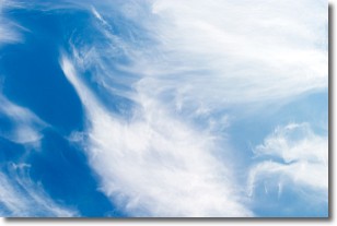
Weather Topic: What are Altostratus Clouds?
Home - Education - Cloud Types - Altostratus Clouds
 Next Topic: Cirrocumulus Clouds
Altostratus clouds form at mid to high-level altitudes
(between 2 and 7 km) and are created by a warm, stable air mass which causes
water vapor
to condense as it rise through the atmosphere. Usually altostratus clouds are
featureless sheets characterized by a uniform color.
In some cases, wind punching through the cloud formation may give it a waved
appearance, called altostratus undulatus. Altostratus clouds
are commonly seen with other cloud formations accompanying them.
Next Topic: Cirrocumulus Clouds
Current conditions powered by WeatherAPI.com


