Weather Alert in Oregon
Special Weather Statement issued August 22 at 1:26AM PDT by NWS Portland OR
AREAS AFFECTED: East Portland Metro; West Columbia River Gorge of Oregon above 500 ft; West Columbia River Gorge I-84 Corridor; Central Columbia River Gorge I-84 Corridor; East Clark County Lowlands; West Columbia River Gorge - SR 14; Central Columbia River Gorge - SR 14; South Washington Cascades
DESCRIPTION: Breezy easterly winds are expected through Friday night for the Columbia River Gorge and adjacent Cascade ridgetops and late Friday morning through Friday evening for the eastern Portland/Vancouver metro. Winds will be strongest on exposed ridgetops where wind gusts will most likely peak between 25-35 mph. Elsewhere, expect wind gusts between 15-20 mph, except up to 30 mph in the western Columbia River Gorge. The breezy east winds will occur simultaneously with low relative humidity values of 20-30% or less, resulting in near critical fire weather conditions. Due to recent rains in the area, larger fuels (such as trees and shrubs) are not dry enough to cause rapid fire spread, but the hot weather will allow fine fuels (such as grasses) to dry out quickly, allowing for potential rapid spread. Use extra caution with potential ignition sources, especially in grassy areas. Outdoor burning is not recommended.
INSTRUCTION: N/A
Want more detail? Get the Complete 7 Day and Night Detailed Forecast!
Current U.S. National Radar--Current
The Current National Weather Radar is shown below with a UTC Time (subtract 5 hours from UTC to get Eastern Time).

National Weather Forecast--Current
The Current National Weather Forecast and National Weather Map are shown below.

National Weather Forecast for Tomorrow
Tomorrow National Weather Forecast and Tomorrow National Weather Map are show below.

North America Water Vapor (Moisture)
This map shows recent moisture content over North America. Bright and colored areas show high moisture (ie, clouds); brown indicates very little moisture present; black indicates no moisture.

Weather Topic: What are Fractus Clouds?
Home - Education - Cloud Types - Fractus Clouds
 Next Topic: Freezing Rain
A fractus cloud (scud) is a fragmented, tattered cloud which has
likely been sheared off of another cloud. They are accessory clouds, meaning they
develop from parent clouds, and are named in a way which describes the original
cloud which contained them.
Fractus clouds which have originated from cumulus clouds are referred to as
cumulus fractus, while fractus clouds which have originated from stratus clouds
are referred to as stratus fractus. Under certain conditions a fractus cloud might
merge with another cloud, or develop into a cumulus cloud, but usually a
fractus cloud seen by itself will dissipate rapidly.
They are often observed on the leading and trailing edges of storm clouds,
and are a display of wind activity.
Next Topic: Freezing Rain
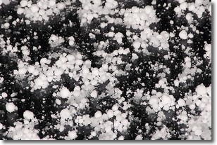
Weather Topic: What is Graupel?
Home - Education - Precipitation - Graupel
 Next Topic: Hail
Graupel is a form of precipitation that is created by atmospheric conditions
which cause supercooled water droplets to contact snow crystals and freeze to
their surface.
Sometimes known as soft hail or snow pellets, graupel is delicate and easily
destroyed by touch. Whereas hail usually falls during severe weather, graupel
doesn't require such conditions to form, and can form in mild precipitation
similar to situations which produce snowfall.
Next Topic: Hail
Current conditions powered by WeatherAPI.com


