Weather Alert in Washington
Hydrologic Outlook issued March 20 at 4:38PM PDT by NWS Pendleton OR
AREAS AFFECTED: Kittitas Valley; Yakima Valley; Lower Columbia Basin of Washington; Simcoe Highlands; Upper Slopes of the Eastern Washington Cascades Crest; Lower Slopes of the Eastern Washington Cascades Crest
DESCRIPTION: ESFPDT Moderate rain is expected to continue along the Washington Cascade crest through tonight before ending Saturday morning. Temperatures are cooling but will remain above freezing during the day, Snowmelt is expected to continue but at decreasing levels. The rain and snow melt will keep water levels high in rivers and streams flowing off the Cascades. The Naches River at Naches and the Yakima River at Easton, Umtanum, Parker and Kiona are expected to remain at or rise above minor flood stage through Sunday evening and Flood Warnings have been issued for those locations. The Naches River at Cliffdell and several locations on the Yakima River are either above action stage or are expected to reach action stage at times through this weekend. Other streams and rivers will continue to have elevated water levels. Please monitor the latest river forecasts from the National Weather Service for additional information.
INSTRUCTION: N/A
Want more detail? Get the Complete 7 Day and Night Detailed Forecast!
Current U.S. National Radar--Current
The Current National Weather Radar is shown below with a UTC Time (subtract 5 hours from UTC to get Eastern Time).

National Weather Forecast--Current
The Current National Weather Forecast and National Weather Map are shown below.

National Weather Forecast for Tomorrow
Tomorrow National Weather Forecast and Tomorrow National Weather Map are show below.

North America Water Vapor (Moisture)
This map shows recent moisture content over North America. Bright and colored areas show high moisture (ie, clouds); brown indicates very little moisture present; black indicates no moisture.

Weather Topic: What is Snow?
Home - Education - Precipitation - Snow
 Next Topic: Stratocumulus Clouds
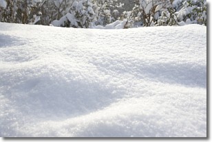
Snow is precipitation taking the form of ice crystals. Each ice crystal, or snowflake,
has unique characteristics, but all of them grow in a hexagonal structure.
Snowfall can last for sustained periods of time and result in significant buildup
of snow on the ground.
On the earth's surface, snow starts out light and powdery, but as it begins to melt
it tends to become more granular, producing small bits of ice which have the consistency of
sand. After several cycles of melting and freezing, snow can become very dense
and ice-like, commonly known as snow pack.
Next Topic: Stratocumulus Clouds
Weather Topic: What are Stratus Clouds?
Home - Education - Cloud Types - Stratus Clouds
 Next Topic: Wall Clouds
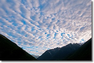
Stratus clouds are similar to altostratus clouds, but form at a
lower altitude and are identified by their fog-like appearance, lacking the
distinguishing features of most clouds.
Stratus clouds are wider than most clouds, and their base has a smooth, uniform
look which is lighter in color than a nimbostratus cloud.
The presence of a stratus cloud indicates the possibility of minor precipitation,
such as drizzle, but heavier precipitation does not typically arrive in the form
of a stratus cloud.
Next Topic: Wall Clouds
Current conditions powered by WeatherAPI.com


