Weather Alert in Alaska
Special Weather Statement issued September 7 at 2:50PM AKDT by NWS Juneau AK
AREAS AFFECTED: City and Borough of Yakutat; Municipality of Skagway; Haines Borough and Klukwan; Glacier Bay; Eastern Chichagof Island; Cape Fairweather to Lisianski Strait; City and Borough of Sitka; Admiralty Island; City and Borough of Juneau; Petersburg Borough; Western Kupreanof and Kuiu Island; Prince of Wales Island; City and Borough of Wrangell; Ketchikan Gateway Borough; Annette Island
DESCRIPTION: A WET FALL STORM WILL BE IMPACTING THE PANHANDLE EARLY WEDNESDAY INTO THURSDAY NIGHT DROPPING AROUND 2 TO 4 INCHES OF RAIN FOR THE LOWER ELEVATIONS AND UP TO 6 INCHES FOR THE HIGHER ELEVATIONS OF THE PANHANDLE. FREEZING LEVELS ARE STILL HIGH AROUND 8000 TO 9000 FT ACROSS THE AREA SO MOST OF THE PRECIPITATION THAT FALLS AT ELEVATION WILL BE RAIN. AREA RIVERS AND STREAMS ARE EXPECTED TO EXPERIENCE RISES IN WATER LEVELS AND INCREASED FLOWS WEDNESDAY INTO THURSDAY IN RESPONSE TO THE HEAVIER RAINFALL, AND MAY STAY HIGH INTO FRIDAY. STAY TUNED FOR MORE UPDATES AS WE GET CLOSER TO THE EVENT.
INSTRUCTION: N/A
Want more detail? Get the Complete 7 Day and Night Detailed Forecast!
Current U.S. National Radar--Current
The Current National Weather Radar is shown below with a UTC Time (subtract 5 hours from UTC to get Eastern Time).

National Weather Forecast--Current
The Current National Weather Forecast and National Weather Map are shown below.

National Weather Forecast for Tomorrow
Tomorrow National Weather Forecast and Tomorrow National Weather Map are show below.

North America Water Vapor (Moisture)
This map shows recent moisture content over North America. Bright and colored areas show high moisture (ie, clouds); brown indicates very little moisture present; black indicates no moisture.

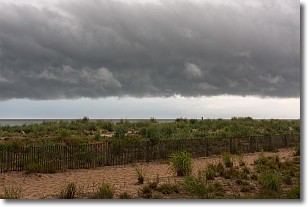
Weather Topic: What are Shelf Clouds?
Home - Education - Cloud Types - Shelf Clouds
 Next Topic: Sleet
A shelf cloud is similar to a wall cloud, but forms at the front
of a storm cloud, instead of at the rear, where wall clouds form.
A shelf cloud is caused by a series of events set into motion by the advancing
storm; first, cool air settles along the ground where precipitation has just fallen.
As the cool air is brought in, the warmer air is displaced, and rises above it,
because it is less dense. When the warmer air reaches the bottom of the storm cloud,
it begins to cool again, and the resulting condensation is a visible shelf cloud.
Next Topic: Sleet
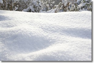
Weather Topic: What is Snow?
Home - Education - Precipitation - Snow
 Next Topic: Stratocumulus Clouds
Snow is precipitation taking the form of ice crystals. Each ice crystal, or snowflake,
has unique characteristics, but all of them grow in a hexagonal structure.
Snowfall can last for sustained periods of time and result in significant buildup
of snow on the ground.
On the earth's surface, snow starts out light and powdery, but as it begins to melt
it tends to become more granular, producing small bits of ice which have the consistency of
sand. After several cycles of melting and freezing, snow can become very dense
and ice-like, commonly known as snow pack.
Next Topic: Stratocumulus Clouds
Current conditions powered by WeatherAPI.com


