Weather Alert in Pennsylvania
Cold Weather Advisory issued February 8 at 12:37AM EST until February 9 at 10:00AM EST by NWS Binghamton NY
AREAS AFFECTED: Wyoming; Lackawanna; Luzerne
DESCRIPTION: * WHAT...For the Extreme Cold Warning, dangerously cold wind chills as low as 28 below. For the Cold Weather Advisory, very cold wind chills as low as 18 below expected. * WHERE...Lackawanna, Luzerne, and Wyoming Counties. * WHEN...For the Extreme Cold Warning, until 1 PM EST this afternoon. For the Cold Weather Advisory, from 1 PM this afternoon to 10 AM EST Monday. * IMPACTS...The dangerously cold wind chills as low as 30 below zero could cause frostbite on exposed skin in as little as 30 minutes. Hypothermia is also possible from prolonged exposure to the cold. * ADDITIONAL DETAILS...The coldest wind chills are expected over the exposed, higher this morning. Wind gusts gradually diminish on Sunday, falling below 30 mph for most locations. The coldest wind chills tonight and Monday look to be around sunrise Monday morning.
INSTRUCTION: Dress in layers including a hat, face mask, and gloves if you must go outside or travel. To prevent water pipes from freezing; wrap or drain or allow them to drip slowly. Keep pets indoors as much as possible. Make frequent checks on older family, friends, and neighbors. Ensure portable heaters are used correctly. Do not use generators or grills inside.
Want more detail? Get the Complete 7 Day and Night Detailed Forecast!
Current U.S. National Radar--Current
The Current National Weather Radar is shown below with a UTC Time (subtract 5 hours from UTC to get Eastern Time).

National Weather Forecast--Current
The Current National Weather Forecast and National Weather Map are shown below.

National Weather Forecast for Tomorrow
Tomorrow National Weather Forecast and Tomorrow National Weather Map are show below.

North America Water Vapor (Moisture)
This map shows recent moisture content over North America. Bright and colored areas show high moisture (ie, clouds); brown indicates very little moisture present; black indicates no moisture.

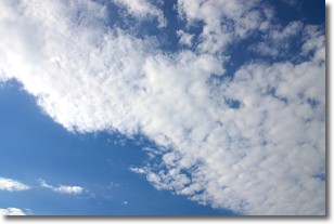
Weather Topic: What are Altocumulus Clouds?
Home - Education - Cloud Types - Altocumulus Clouds
 Next Topic: Altostratus Clouds
Similar to cirrocumulus clouds, altocumulus clouds are
characterized by cloud patches. They are distinguished by larger cloudlets
than cirrocumulus clouds but are still smaller than stratocumulus clouds.
Altocumulus clouds most commonly form in middle altitudes (between 2 and 5 km)
and may resemble, at times, the shape of a flying saucer.
These uncommon formations, called altocumulus lenticularis, are created by uplift
in the atmosphere and are most often seen in close proximity to mountains.
Next Topic: Altostratus Clouds
Weather Topic: What are Cirrocumulus Clouds?
Home - Education - Cloud Types - Cirrocumulus Clouds
 Next Topic: Cirrostratus Clouds
Cirrocumulus clouds form at high altitudes (usually around 5 km)
and have distinguishing characteristics displayed in a fine layer of
small cloud patches. These small cloud patches are sometimes referred to as
"cloudlets" in relation to the whole cloud formation.
Cirrocumulus clouds are formed from ice crystals and water droplets. Often, the
water droplets in the cloud freeze into ice crystals and the cloud becomes a
cirrostratus cloud. Because of this common occurrence, cirrocumulus cloud
formations generally pass rapidly.
Next Topic: Cirrostratus Clouds
Current conditions powered by WeatherAPI.com


