Weather Alert in Oklahoma
Red Flag Warning issued March 26 at 1:35PM CDT until March 26 at 10:00PM CDT by NWS Norman OK
AREAS AFFECTED: Harper; Woods; Alfalfa; Grant; Kay; Ellis; Woodward; Major; Garfield; Noble; Roger Mills; Dewey; Custer; Blaine; Kingfisher; Logan; Payne; Beckham; Washita; Caddo; Canadian; Oklahoma; Lincoln; Grady; McClain; Cleveland; Pottawatomie; Harmon; Greer; Kiowa; Jackson; Tillman; Comanche; Stephens; Garvin; Cotton; Jefferson; Hardeman; Foard; Wilbarger; Wichita; Knox; Baylor; Archer; Clay
DESCRIPTION: ...Wind driven near critical to critical fire weather conditions will continue today and tomorrow including a significant wind shift tonight from southerly winds to northerly winds.... ...RED FLAG WARNING IN EFFECT FROM 10 AM TO 9 PM CDT FRIDAY FOR HOT...DRY...AND WINDY CONDITIONS FOR WESTERN...NORTHERN... AND CENTRAL OKLAHOMA AND WESTERN NORTH TEXAS... * WINDS Thursday... South 25 to 35 mph with gusts up to 40 to 45 mph. A wind shift to northerly is expected this evening and overnight. * RELATIVE HUMIDITY Thursday... as low as 10 to 15 percent. * TEMPERATURES Thursday...Up to 95 to 100 degrees. * SEVERITY Thursday... FUELS (ERC)...90th+ percentile...5 (out of 5). WEATHER...Critical...3 (out of 5). FIRE ENVIRONMENT...8 (out of 10). * WINDS Friday...North to Northeast 25 to 35 mph with gusts up to 55 mph. * RELATIVE HUMIDITY Friday...As low as 15 to 20 percent. * TEMPERATURES Friday...Up to 60 to 65 degrees. * SEVERITY Friday... FUELS (ERC)...90th+ percentile...5 (out of 5). WEATHER...Near Critical...2 (out of 5). FIRE ENVIRONMENT...7 (out of 10). * IMPACTS...Any fires that develop will likely spread rapidly. Outdoor burning is not recommended.
INSTRUCTION: A Red Flag Warning means that critical fire weather conditions are either occurring now, or will shortly. A combination of strong winds, low relative humidity, and warm temperatures will contribute to extreme fire behavior.
Want more detail? Get the Complete 7 Day and Night Detailed Forecast!
Current U.S. National Radar--Current
The Current National Weather Radar is shown below with a UTC Time (subtract 5 hours from UTC to get Eastern Time).

National Weather Forecast--Current
The Current National Weather Forecast and National Weather Map are shown below.

National Weather Forecast for Tomorrow
Tomorrow National Weather Forecast and Tomorrow National Weather Map are show below.

North America Water Vapor (Moisture)
This map shows recent moisture content over North America. Bright and colored areas show high moisture (ie, clouds); brown indicates very little moisture present; black indicates no moisture.

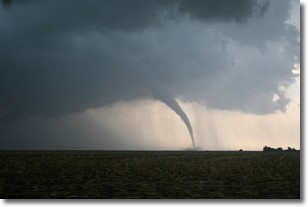
Weather Topic: What are Wall Clouds?
Home - Education - Cloud Types - Wall Clouds
 Next Topic: Altocumulus Clouds
A wall cloud forms underneath the base of a cumulonimbus cloud,
and can be a hotbed for deadly tornadoes.
Wall clouds are formed by air flowing into the cumulonimbus clouds, which can
result in the wall cloud descending from the base of the cumulonimbus cloud, or
rising fractus clouds which join to the base of the storm cloud as the wall cloud
takes shape.
Wall clouds can be very large, and in the Northern Hemisphere they generally
form at the southern edge of cumulonimbus clouds.
Next Topic: Altocumulus Clouds
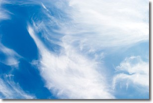
Weather Topic: What are Altostratus Clouds?
Home - Education - Cloud Types - Altostratus Clouds
 Next Topic: Cirrocumulus Clouds
Altostratus clouds form at mid to high-level altitudes
(between 2 and 7 km) and are created by a warm, stable air mass which causes
water vapor
to condense as it rise through the atmosphere. Usually altostratus clouds are
featureless sheets characterized by a uniform color.
In some cases, wind punching through the cloud formation may give it a waved
appearance, called altostratus undulatus. Altostratus clouds
are commonly seen with other cloud formations accompanying them.
Next Topic: Cirrocumulus Clouds
Current conditions powered by WeatherAPI.com


