Weather Alert in Washington
Flood Warning issued March 26 at 4:48PM PDT until April 2 at 8:30AM PDT by NWS Spokane WA
AREAS AFFECTED: Chelan, WA
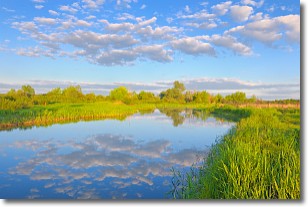
DESCRIPTION: * WHAT...Flooding caused by rain and snowmelt is expected for the lower Stehekin Valley. * WHERE...A portion of North Central Washington, including the following county, Chelan. * WHEN...Until further notice. * IMPACTS...When the Stehekin River gauge hits 19.3 feet, water breaches the river bank. At 20 feet, water inundates some properties and overtops the temporary corduroy bridge. Company Creek Road begins to flood in places at the northern end and Battalion Creek culverts are beginning to be overtopped. At 20.5 feet, water begins to damage Wood Road. * ADDITIONAL DETAILS... - At 418 PM PDT, Thursday, March 26th, the Stehekin River was at 20.64 feet and it is forecast to slowly recede to around 20.1 feet by Saturday evening. It is forecasted to stay above 20 feet until further notice. - Gauge reports of between 0.60 and 0.90 inches of rain have fallen in the headwaters of the Stehekin River over a 48 hour period through 400 PM Thursday. Snow melt is also occurring and contributing to rises. - http://www.weather.gov/safety/flood
INSTRUCTION: Those living in areas prone to flooding should be prepared to take action should flooding develop.
Want more detail? Get the Complete 7 Day and Night Detailed Forecast!
Current U.S. National Radar--Current
The Current National Weather Radar is shown below with a UTC Time (subtract 5 hours from UTC to get Eastern Time).

National Weather Forecast--Current
The Current National Weather Forecast and National Weather Map are shown below.

National Weather Forecast for Tomorrow
Tomorrow National Weather Forecast and Tomorrow National Weather Map are show below.

North America Water Vapor (Moisture)
This map shows recent moisture content over North America. Bright and colored areas show high moisture (ie, clouds); brown indicates very little moisture present; black indicates no moisture.

Weather Topic: What are Stratocumulus Clouds?
Home - Education - Cloud Types - Stratocumulus Clouds
 Next Topic: Stratus Clouds
Stratocumulus clouds are similar to altocumulus clouds in their
fluffy appearance, but have a slightly darker shade due to their additional mass.
A good way to distinguish the two cloud types is to hold your hand out and measure
the size of an individual cloud; if it is the size of your thumb it is generally
an altocumulus cloud, if it is the size of your hand it is generally a
stratocumulus cloud.
It is uncommon for stratocumulus clouds to produce precipitation, but if they do
it is usually a light rain or snow.
Next Topic: Stratus Clouds
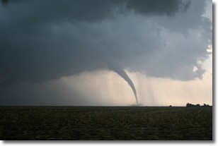
Weather Topic: What are Wall Clouds?
Home - Education - Cloud Types - Wall Clouds
 Next Topic: Altocumulus Clouds
A wall cloud forms underneath the base of a cumulonimbus cloud,
and can be a hotbed for deadly tornadoes.
Wall clouds are formed by air flowing into the cumulonimbus clouds, which can
result in the wall cloud descending from the base of the cumulonimbus cloud, or
rising fractus clouds which join to the base of the storm cloud as the wall cloud
takes shape.
Wall clouds can be very large, and in the Northern Hemisphere they generally
form at the southern edge of cumulonimbus clouds.
Next Topic: Altocumulus Clouds
Current conditions powered by WeatherAPI.com


