Weather Alert in Pennsylvania
Special Weather Statement issued August 22 at 6:51AM EDT by NWS State College PA
AREAS AFFECTED: Warren; McKean; Potter; Elk; Cameron; Northern Clinton; Clearfield; Northern Centre; Southern Centre; Blair; Huntingdon; Mifflin; Juniata; Bedford; Fulton; Tioga; Northern Lycoming; Sullivan; Southern Clinton; Southern Lycoming; Union; Snyder; Montour; Northumberland; Columbia; Schuylkill
DESCRIPTION: Locally dense fog formed early today throughout the valleys of Central and Northern Pennsylvania, as a result of clearing skies, near calm air and a large difference of around 20 degrees between the air, river and stream temperatures. The fog will reduce the visibility below one quarter of a mile in some places. Allow extra time to travel to work or school this morning, and ensure that you keep plenty of braking distance between you and the vehicle ahead. Visibility will improve as the fog dissipates between 9 and 10 AM.
INSTRUCTION: N/A
Want more detail? Get the Complete 7 Day and Night Detailed Forecast!
Current U.S. National Radar--Current
The Current National Weather Radar is shown below with a UTC Time (subtract 5 hours from UTC to get Eastern Time).

National Weather Forecast--Current
The Current National Weather Forecast and National Weather Map are shown below.

National Weather Forecast for Tomorrow
Tomorrow National Weather Forecast and Tomorrow National Weather Map are show below.

North America Water Vapor (Moisture)
This map shows recent moisture content over North America. Bright and colored areas show high moisture (ie, clouds); brown indicates very little moisture present; black indicates no moisture.

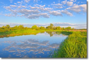
Weather Topic: What are Stratocumulus Clouds?
Home - Education - Cloud Types - Stratocumulus Clouds
 Next Topic: Stratus Clouds
Stratocumulus clouds are similar to altocumulus clouds in their
fluffy appearance, but have a slightly darker shade due to their additional mass.
A good way to distinguish the two cloud types is to hold your hand out and measure
the size of an individual cloud; if it is the size of your thumb it is generally
an altocumulus cloud, if it is the size of your hand it is generally a
stratocumulus cloud.
It is uncommon for stratocumulus clouds to produce precipitation, but if they do
it is usually a light rain or snow.
Next Topic: Stratus Clouds
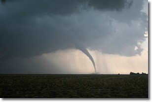
Weather Topic: What are Wall Clouds?
Home - Education - Cloud Types - Wall Clouds
 Next Topic: Altocumulus Clouds
A wall cloud forms underneath the base of a cumulonimbus cloud,
and can be a hotbed for deadly tornadoes.
Wall clouds are formed by air flowing into the cumulonimbus clouds, which can
result in the wall cloud descending from the base of the cumulonimbus cloud, or
rising fractus clouds which join to the base of the storm cloud as the wall cloud
takes shape.
Wall clouds can be very large, and in the Northern Hemisphere they generally
form at the southern edge of cumulonimbus clouds.
Next Topic: Altocumulus Clouds
Current conditions powered by WeatherAPI.com


