Weather Alert in Minnesota
Winter Weather Advisory issued April 4 at 5:07AM CDT until April 4 at 10:00PM CDT by NWS Twin Cities/Chanhassen MN
AREAS AFFECTED: Mille Lacs; Kanabec; Stearns; Benton; Sherburne; Isanti; Chisago; Meeker; Wright; McLeod; Polk; Barron; Rusk
DESCRIPTION: ...MIXED WINTER EVENT WITH SNOW AND ICE ACCUMULATION THROUGH THIS EVENING... .Widespread precipitation continues early this morning, with snow across western and central Minnesota, freezing rain across east-central Minnesota into northern Wisconsin, and light rain to the south. The heaviest snow is falling across west-central Minnesota, while the greatest ice accumulations are expected from extreme east-central Minnesota into northern Wisconsin. Light snow will end from west to east this afternoon and evening with breezy northwesterly winds. * WHAT...Mixed precipitation. Additional snow accumulations up to 3 inches in Minnesota and up to 1 inch in Wisconsin. Additional ice accumulations up to one tenth of an inch in Wisconsin. The highest snow amounts will be across a line from western Stearns County to northern Kanabec County. The greatest ice accumulations will be across a line from Isanti County to northern Rusk County. * WHERE...In Minnesota, Benton, McLeod, Meeker, Sherburne, Stearns, Wright, Chisago, Isanti, Kanabec, and Mille Lacs Counties. In Wisconsin, Barron, Polk, and Rusk Counties. * WHEN...Until 10 PM CDT this evening. * IMPACTS...Plan on slippery road conditions.
INSTRUCTION: Slow down and use caution while traveling. In Minnesota, call 5 1 1 or visit 511mn.org for road conditions. In Wisconsin, call 5 1 1 or visit 511wi.gov for road conditions.
Want more detail? Get the Complete 7 Day and Night Detailed Forecast!
Current U.S. National Radar--Current
The Current National Weather Radar is shown below with a UTC Time (subtract 5 hours from UTC to get Eastern Time).

National Weather Forecast--Current
The Current National Weather Forecast and National Weather Map are shown below.

National Weather Forecast for Tomorrow
Tomorrow National Weather Forecast and Tomorrow National Weather Map are show below.

North America Water Vapor (Moisture)
This map shows recent moisture content over North America. Bright and colored areas show high moisture (ie, clouds); brown indicates very little moisture present; black indicates no moisture.

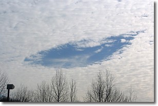
Weather Topic: What are Hole Punch Clouds?
Home - Education - Cloud Types - Hole Punch Clouds
 Next Topic: Mammatus Clouds
A hole punch cloud is an unusual occurrence when a disk-shaped
hole appears in a cirrostratus, cirrocumulus, or altocumulus cloud.
When part of the cloud forms ice crystals, water droplets in the surrounding area
of the cloud evaporate. The effect of this process produces a large elliptical
gap in the cloud. The hole punch cloud formation is rare, but it is not specific
to any geographic area.
Other names which have been used to describe this phenomena include fallstreak hole,
skypunch, and cloud hole.
Next Topic: Mammatus Clouds
Weather Topic: What are Nimbostratus Clouds?
Home - Education - Cloud Types - Nimbostratus Clouds
 Next Topic: Precipitation
A nimbostratus cloud is similar to a stratus cloud in its formless,
smooth appearance. However, a nimbostratus cloud is darker than a stratus cloud,
because it is thicker.
Unlike a stratus cloud, a nimbostratus cloud typically brings with it the threat
of moderate to heavy precipitation. In some cases, the precipitation may evaporate
before reaching the ground, a phenomenon known as virga.
Next Topic: Precipitation
Current conditions powered by WeatherAPI.com


