Weather Alert in New York
Special Weather Statement issued September 4 at 4:31AM EDT by NWS Albany NY
AREAS AFFECTED: Northern Saratoga; Northern Warren; Northern Washington; Western Schenectady; Eastern Schenectady; Southern Saratoga; Western Albany; Eastern Albany; Western Rensselaer; Eastern Rensselaer; Eastern Greene; Western Columbia; Eastern Columbia; Eastern Ulster; Western Dutchess; Eastern Dutchess; Southeast Warren; Southern Washington
DESCRIPTION: The combination of dry fuels, southerly winds gusting between 25 and 35 mph, and relative humidity values between 35 and 40 percent will contribute to an elevated risk for fire spread today. The risk of fire spread will be highest in the Upper Hudson Valley/Champlain and Hudson Valley Fire Danger Rating Areas. This includes Warren, Saratoga, Washington, Schenectady, Albany, Rensselaer, Columbia, Dutchess, eastern Greene and eastern Ulster Counties. Any fires that develop in these areas could spread rapidly and become difficult to contain. Residents are encouraged to exercise caution if handling any potential ignition sources, such as machinery, cigarettes, or matches. This product was issued in coordination the the New York State Department of Environmental Conservation. For more information about wildfire danger and wildfire prevention, please visit their website at http://dec.ny.gov/environmental-protection/wildfires.
INSTRUCTION: N/A
Want more detail? Get the Complete 7 Day and Night Detailed Forecast!
Current U.S. National Radar--Current
The Current National Weather Radar is shown below with a UTC Time (subtract 5 hours from UTC to get Eastern Time).

National Weather Forecast--Current
The Current National Weather Forecast and National Weather Map are shown below.

National Weather Forecast for Tomorrow
Tomorrow National Weather Forecast and Tomorrow National Weather Map are show below.

North America Water Vapor (Moisture)
This map shows recent moisture content over North America. Bright and colored areas show high moisture (ie, clouds); brown indicates very little moisture present; black indicates no moisture.

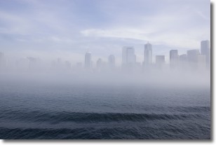
Weather Topic: What is Fog?
Home - Education - Cloud Types - Fog
 Next Topic: Fractus Clouds
Fog is technically a type of stratus cloud, which lies along the
ground and obscures visibility.
It is usually created when humidity in the air condenses into tiny water droplets.
Because of this, some places are more prone to foggy weather, such as regions
close to a body of water.
Fog is similar to mist; both are the appearance of water droplets suspended in
the air, but fog is the term applied to the condition when visibility is less than 1 km.
Next Topic: Fractus Clouds
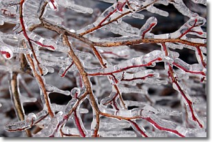
Weather Topic: What is Freezing Rain?
Home - Education - Precipitation - Freezing Rain
 Next Topic: Graupel
Freezing rain is a condition where precipitation which has fallen in the form of
water droplets reaches temperatures which are below freezing and freezes upon
coming into contact
with surface objects. The result of this precipitation is a glaze of ice which
can be damaging to plants and man-made structures. A severe onset of freezing
rain which results in a very thick glaze of ice is known as an ice storm.
Next Topic: Graupel
Current conditions powered by WeatherAPI.com


