Weather Alert in Nebraska
Flood Watch issued February 7 at 10:36AM CST until February 9 at 10:00PM CST by NWS Omaha/Valley NE
AREAS AFFECTED: Antelope; Pierce; Madison; Stanton; Cuming; Platte; Colfax; Dodge; Washington; Butler; Saunders; Douglas; Sarpy; Cass
DESCRIPTION: A watch remains in effect for the Platte, Elkhorn and Loup rivers due to potential ice jam development. This heightened threat is due to persistent warm weather. Those with interests along area rivers, especially in low-lying areas, should remain vigilant to the potential for rapidly rising water. * WHAT...Flooding caused by an ice jam continues to be possible. * WHERE...Portions of east central, northeast, and southeast Nebraska, including the following counties, in east central Nebraska, Butler, Dodge, Douglas, Sarpy, Saunders and Washington. In northeast Nebraska, Antelope, Colfax, Cuming, Madison, Pierce, Platte and Stanton. In southeast Nebraska, Cass. * WHEN...Through Monday evening. * IMPACTS...The formation of an ice jam could result in sudden rises of water, leading to a rapid flooding situation. Ice jams can cause water level fluctuations of 1 to 3 feet over a very short time period and without much notice. * ADDITIONAL DETAILS... - While no ice movement has been observed or reported, several consecutive days of highs ranging from the upper 40s to mid 60s suggest breakup and movement is imminent.
INSTRUCTION: You should monitor later forecasts and be alert for possible Flood Warnings. Those living in areas prone to flooding should be prepared to take action should flooding develop.
Want more detail? Get the Complete 7 Day and Night Detailed Forecast!
Current U.S. National Radar--Current
The Current National Weather Radar is shown below with a UTC Time (subtract 5 hours from UTC to get Eastern Time).

National Weather Forecast--Current
The Current National Weather Forecast and National Weather Map are shown below.

National Weather Forecast for Tomorrow
Tomorrow National Weather Forecast and Tomorrow National Weather Map are show below.

North America Water Vapor (Moisture)
This map shows recent moisture content over North America. Bright and colored areas show high moisture (ie, clouds); brown indicates very little moisture present; black indicates no moisture.

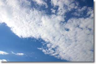
Weather Topic: What are Stratus Clouds?
Home - Education - Cloud Types - Stratus Clouds
 Next Topic: Wall Clouds
Stratus clouds are similar to altostratus clouds, but form at a
lower altitude and are identified by their fog-like appearance, lacking the
distinguishing features of most clouds.
Stratus clouds are wider than most clouds, and their base has a smooth, uniform
look which is lighter in color than a nimbostratus cloud.
The presence of a stratus cloud indicates the possibility of minor precipitation,
such as drizzle, but heavier precipitation does not typically arrive in the form
of a stratus cloud.
Next Topic: Wall Clouds
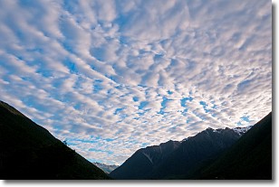
Weather Topic: What are Altocumulus Clouds?
Home - Education - Cloud Types - Altocumulus Clouds
 Next Topic: Altostratus Clouds
Similar to cirrocumulus clouds, altocumulus clouds are
characterized by cloud patches. They are distinguished by larger cloudlets
than cirrocumulus clouds but are still smaller than stratocumulus clouds.
Altocumulus clouds most commonly form in middle altitudes (between 2 and 5 km)
and may resemble, at times, the shape of a flying saucer.
These uncommon formations, called altocumulus lenticularis, are created by uplift
in the atmosphere and are most often seen in close proximity to mountains.
Next Topic: Altostratus Clouds
Current conditions powered by WeatherAPI.com


